Pýthio geodata
Pýthio (Thessaly) is a populated place; located in Greece in Europe/Athens (GMT+3) time zone. With population of 892 people, there are 1139 cities with bigger population in this country. Compared to other cities in Greece, 67.3% of cities are located further ↓South; 66.7% of cities are located further →East and 96.2% of cities have lower elevation than Pýthio. Note1


Pýthio GPS coordinates[2]
40° 3' 58.284" North, 22° 13' 52.608" East
| Map corner | latitude | longitude |
|---|---|---|
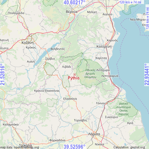
| Upper-left | 40.60217°, | 21.52816° |
| Center: | 40.06619°, | 22.23128° |
| Lower-right: | 39.52596°, | 22.93441° |
| Map W x H: | 119.7×119.7 km | = 74.4×74.4mi |
| max Lat: | 41.72048° ⇑32.7% North |
| Pýthio: | 40.06619° |
| min Lat: | ⇓67.3% South 34.8346° |
| min Long | Pýthio | max Long |
| 19.40494° | 22.23128° | 29.59361° |
| W 33.3%⇐ | ⇒66.7% E |
Elevation
Elevation of Pýthio is 715 m = 2346 ft, and this is 546.1 m = 1792 ft above average elevation for this country.
| Max E: |
1439 m = 4721 ft | 3.8% |
| Pýthio | 715 m 2346 ft | |
| Avg. | 168.9 m = 554 ft | |
Min E: |
0 m = 0 ft | 96.2% |
See also: Greece elevation on elevation.city.
Geographical zone
Pýthio is located in North temperate zone (between Tropic of Cancer and the Arctic Circle). Distance of this Northern Tropic circle is 1849 km =1148.9 mi to South.| Distance of | km | miles | from Pýthio |
|---|---|---|---|
| North Pole | 5552.1 | 3449.9 | to North |
| Arctic Circle | 2946.2 | 1830.7 | to North |
| Tropic Cancer | 1849 | 1148.9 | to South |
| Equator | 4454.9 | 2768.1 | to South |


Nearby cities:
15 places around Pýthio: (largest is in red/bold)
• Elassóna
19.4 km =12.1 mi,  190°
190°
• Kalývia
4.9 km =3 mi,  170°
170°
• Kastaniá
21.4 km =13.3 mi,  304°
304°
• Káto Miliá
23 km =14.3 mi,  24°
24°
• Litóchoro
23 km =14.3 mi,  80°
80°
• Livádi
9.2 km =5.7 mi,  316°
316°
• Lófos
23.5 km =14.6 mi,  32°
32°
• Nea Lava
23.1 km =14.4 mi,  306°
306°
• Platanórevma
23.1 km =14.4 mi, 310°
• Sarantáporo
15.2 km =9.4 mi,  270°
270°
• Sérvia
23.8 km =14.8 mi, 302°
• Tsarítsani
20.6 km =12.8 mi,  180°
180°
• Vrontoú
22.2 km =13.8 mi,  50°
50°
• Ágios Dimítrios
9.9 km =6.2 mi,  359°
359°
• Ázoros
14.9 km =9.3 mi,  240°
240°
Sources, notices
• [Note1] Compared only with cities in Greece existing in our database
• [Src1] Map data: © OpenStreetMap contributors (CC-BY-SA)
• [Src2] Other city data from geonames.org with taken over terms of usage.
• [Src3] Geographical zone / Annual Mean Temperature by Robert A. Rohde @ Wikipedia
