Palaiokómi geodata
Palaiokómi (Central Macedonia) is a populated place; located in Greece in Europe/Athens (GMT+3) time zone. With population of 1,274 people, there are 792 cities with bigger population in this country. Compared to other cities in Greece, 87.8% of cities are located further ↓South; 76.2% of cities are located further ←West and 64.3% of cities have lower elevation than Palaiokómi. Note1
Administrative division(s):
- Level 1: Central Macedonia
- Level 2: Nomós Serrón
- Level 3: Dimos Amfipoli


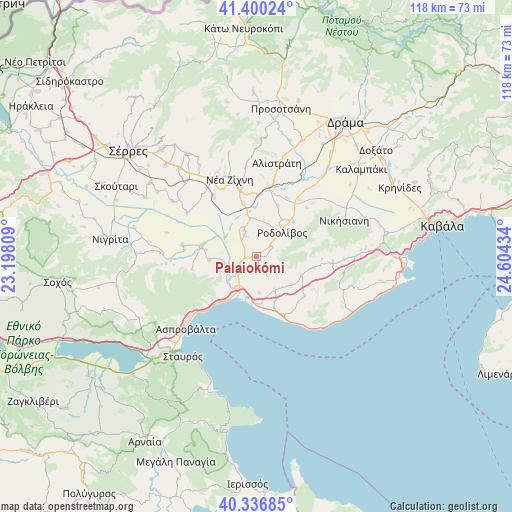
Palaiokómi GPS coordinates[2]
40° 52' 14.448" North, 23° 54' 4.356" East
| Map corner | latitude | longitude |
|---|---|---|
| Upper-left | 41.40024°, | 23.19809° |
| Center: | 40.87068°, | 23.90121° |
| Lower-right: | 40.33685°, | 24.60434° |
| Map W x H: | 118.2×118.2 km | = 73.4×73.4mi |
| max Lat: | 41.72048° ⇑12.2% North |
| Palaiokómi: | 40.87068° |
| min Lat: | ⇓87.8% South 34.8346° |
| min Long | Palaiokómi | max Long |
| 19.40494° | 23.90121° | 29.59361° |
| W 76.2%⇐ | ⇒23.8% E |
Elevation
Elevation of Palaiokómi is 138 m = 453 ft, and this is 30.9 m = 101 ft below average elevation for this country.
| Max E: |
1439 m = 4721 ft | 35.7% |
| Avg. | 168.9 m = 554 ft | |
| Palaiokómi | 138 m = 453 ft | |
Min E: |
0 m = 0 ft | 64.3% |
See also: Greece elevation on elevation.city.
Geographical zone
Palaiokómi is located in North temperate zone (between Tropic of Cancer and the Arctic Circle). Distance of this Northern Tropic circle is 1938.5 km =1204.5 mi to South.| Distance of | km | miles | from Palaiokómi |
|---|---|---|---|
| North Pole | 5462.7 | 3394.4 | to North |
| Arctic Circle | 2856.8 | 1775.1 | to North |
| Tropic Cancer | 1938.5 | 1204.5 | to South |
| Equator | 4544.4 | 2823.8 | to South |


Nearby cities:
15 places around Palaiokómi: (largest is in red/bold)
• Akropótamos
14.5 km =9 mi,  128°
128°
• Dravískos
6.4 km =4 mi,  336°
336°
• Efkarpía
10.9 km =6.8 mi,  265°
265°
• Karianí
14.9 km =9.3 mi,  152°
152°
• Krinída
15.5 km =9.6 mi,  26°
26°
• Mavrothálassa
12.9 km =8 mi,  281°
281°
• Mavrólofos
5.3 km =3.3 mi,  331°
331°
• Néa Kerdýlia
9.8 km =6.1 mi,  210°
210°
• Ofrínion
8.3 km =5.2 mi,  174°
174°
• Orfánio
11.4 km =7.1 mi,  158°
158°
• Paralía Ofryníou
11.6 km =7.2 mi,  180°
180°
• Platanótopos
13.6 km =8.5 mi,  101°
101°
• Podhokhóri
11.3 km =7 mi,  112°
112°
• Próti
11.7 km =7.3 mi,  45°
45°
• Rodolívos
8.3 km =5.2 mi, 48°
Sources, notices
• [Note1] Compared only with cities in Greece existing in our database
• [Src1] Map data: © OpenStreetMap contributors (CC-BY-SA)
• [Src2] Other city data from geonames.org with taken over terms of usage.
• [Src3] Geographical zone / Annual Mean Temperature by Robert A. Rohde @ Wikipedia
