Mavrólofos geodata
Mavrólofos (Central Macedonia) is a populated place; located in Greece in Europe/Athens (GMT+3) time zone. With population of 658 people, there are 1485 cities with bigger population in this country. Compared to other cities in Greece, 88.9% of cities are located further ↓South; 75.4% of cities are located further ←West and 56.5% of cities have lower elevation than Mavrólofos. Note1
Administrative division(s):
- Level 1: Central Macedonia
- Level 2: Nomós Serrón
- Level 3: Dimos Nea Zichni


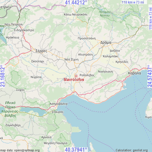
Mavrólofos GPS coordinates[2]
40° 54' 46.44" North, 23° 52' 16.464" East
| Map corner | latitude | longitude |
|---|---|---|
| Upper-left | 41.44212°, | 23.16812° |
| Center: | 40.9129°, | 23.87124° |
| Lower-right: | 40.37941°, | 24.57437° |
| Map W x H: | 118.2×118.2 km | = 73.4×73.4mi |
| max Lat: | 41.72048° ⇑11.1% North |
| Mavrólofos: | 40.9129° |
| min Lat: | ⇓88.9% South 34.8346° |
| min Long | Mavrólofos | max Long |
| 19.40494° | 23.87124° | 29.59361° |
| W 75.4%⇐ | ⇒24.6% E |
Elevation
Elevation of Mavrólofos is 103 m = 338 ft, and this is 65.9 m = 216 ft below average elevation for this country.
| Max E: |
1439 m = 4721 ft | 43.5% |
| Avg. | 168.9 m = 554 ft | |
| Mavrólofos | 103 m = 338 ft | |
Min E: |
0 m = 0 ft | 56.5% |
See also: Greece elevation on elevation.city.
Geographical zone
Mavrólofos is located in North temperate zone (between Tropic of Cancer and the Arctic Circle). Distance of this Northern Tropic circle is 1943.2 km =1207.4 mi to South.| Distance of | km | miles | from Mavrólofos |
|---|---|---|---|
| North Pole | 5458 | 3391.4 | to North |
| Arctic Circle | 2852.1 | 1772.2 | to North |
| Tropic Cancer | 1943.2 | 1207.4 | to South |
| Equator | 4549.1 | 2826.7 | to South |


Nearby cities:
15 places around Mavrólofos: (largest is in red/bold)
• Dravískos
1.2 km =0.7 mi,  359°
359°
• Efkarpía
10 km =6.2 mi,  236°
236°
• Gázoros
14.9 km =9.3 mi,  327°
327°
• Krinída
13.1 km =8.1 mi,  46°
46°
• Mavrothálassa
10.4 km =6.5 mi,  258°
258°
• Néa Báfra
15.1 km =9.4 mi,  56°
56°
• Néa Kerdýlia
13.4 km =8.3 mi,  190°
190°
• Néa Zíchni
13.7 km =8.5 mi,  344°
344°
• Ofrínion
13.4 km =8.3 mi,  165°
165°
• Palaiokómi
5.3 km =3.3 mi,  151°
151°
• Podhokhóri
15.8 km =9.8 mi,  125°
125°
• Próti
11.5 km =7.1 mi,  72°
72°
• Rodolívos
8.8 km =5.5 mi,  84°
84°
• Tholós
12.2 km =7.6 mi,  322°
322°
• Ívira
14.6 km =9.1 mi, 262°
Sources, notices
• [Note1] Compared only with cities in Greece existing in our database
• [Src1] Map data: © OpenStreetMap contributors (CC-BY-SA)
• [Src2] Other city data from geonames.org with taken over terms of usage.
• [Src3] Geographical zone / Annual Mean Temperature by Robert A. Rohde @ Wikipedia
