Próti geodata
Próti (Central Macedonia) is a populated place; located in Greece in Europe/Athens (GMT+3) time zone. With population of 1,176 people, there are 846 cities with bigger population in this country. Compared to other cities in Greece, 89.9% of cities are located further ↓South; 78.6% of cities are located further ←West and 80.4% of cities have lower elevation than Próti. Note1
Administrative division(s):
- Level 1: Central Macedonia
- Level 2: Nomós Serrón
- Level 3: Dimos Amfipoli


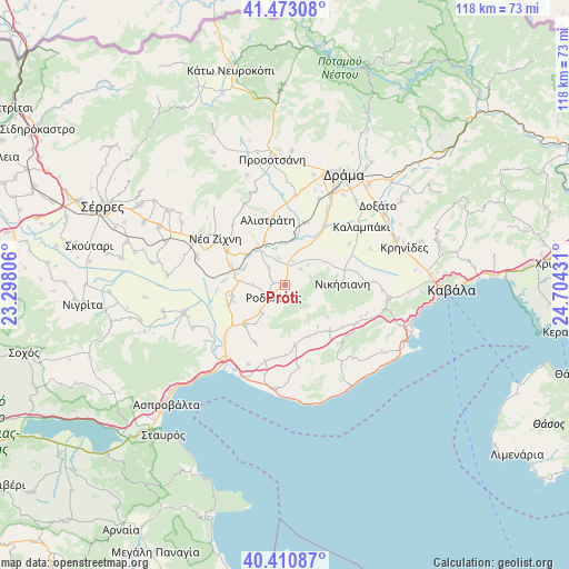
Próti GPS coordinates[2]
40° 56' 38.796" North, 24° 0' 4.248" East
| Map corner | latitude | longitude |
|---|---|---|
| Upper-left | 41.47308°, | 23.29806° |
| Center: | 40.94411°, | 24.00118° |
| Lower-right: | 40.41087°, | 24.70431° |
| Map W x H: | 118.1×118.1 km | = 73.4×73.4mi |
| max Lat: | 41.72048° ⇑10.1% North |
| Próti: | 40.94411° |
| min Lat: | ⇓89.9% South 34.8346° |
| min Long | Próti | max Long |
| 19.40494° | 24.00118° | 29.59361° |
| W 78.6%⇐ | ⇒21.4% E |
Elevation
Elevation of Próti is 282 m = 925 ft, and this is 113.1 m = 371 ft above average elevation for this country.
| Max E: |
1439 m = 4721 ft | 19.6% |
| Próti | 282 m 925 ft | |
| Avg. | 168.9 m = 554 ft | |
Min E: |
0 m = 0 ft | 80.4% |
See also: Greece elevation on elevation.city.
Geographical zone
Próti is located in North temperate zone (between Tropic of Cancer and the Arctic Circle). Distance of this Northern Tropic circle is 1946.6 km =1209.6 mi to South.| Distance of | km | miles | from Próti |
|---|---|---|---|
| North Pole | 5454.5 | 3389.3 | to North |
| Arctic Circle | 2848.6 | 1770 | to North |
| Tropic Cancer | 1946.6 | 1209.6 | to South |
| Equator | 4552.6 | 2828.9 | to South |


Nearby cities:
15 places around Próti: (largest is in red/bold)
• Alistráti
13.9 km =8.6 mi,  344°
344°
• Dravískos
11.1 km =6.9 mi,  258°
258°
• Fotolívos
13.5 km =8.4 mi,  16°
16°
• Georgianí
12.4 km =7.7 mi,  83°
83°
• Kormísta
6.1 km =3.8 mi,  48°
48°
• Krinída
5.8 km =3.6 mi,  345°
345°
• Mavrólofos
11.5 km =7.1 mi,  252°
252°
• Mousthéni
13.1 km =8.1 mi,  134°
134°
• Nikísiani
11.9 km =7.4 mi,  88°
88°
• Néa Báfra
5.2 km =3.2 mi, 18°
• Palaiochóri
14.8 km =9.2 mi, 90°
• Palaiokómi
11.7 km =7.3 mi,  225°
225°
• Platanótopos
11.9 km =7.4 mi,  155°
155°
• Podhokhóri
12.7 km =7.9 mi,  171°
171°
• Rodolívos
3.4 km =2.1 mi,  220°
220°
Sources, notices
• [Note1] Compared only with cities in Greece existing in our database
• [Src1] Map data: © OpenStreetMap contributors (CC-BY-SA)
• [Src2] Other city data from geonames.org with taken over terms of usage.
• [Src3] Geographical zone / Annual Mean Temperature by Robert A. Rohde @ Wikipedia
