Komotiní geodata
Komotiní (East Macedonia and Thrace) is a seat of a first-order administrative division; located in Greece in Europe/Athens (GMT+3) time zone. With population of 45,631 people, there are 45 cities with bigger population in this country. Compared to other cities in Greece, 95.9% of cities are located further ↓South; 90.3% of cities are located further ←West and 64.1% of cities have higher elevation than Komotiní. Note1
Administrative division(s):
- Level 1: East Macedonia and Thrace
- Level 2: Nomós Rodópis
- Level 3: Dimos Komotini


Komotiní GPS coordinates[2]
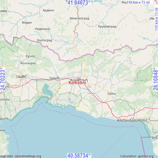
41° 7' 9.012" North, 25° 24' 19.26" East
| Map corner | latitude | longitude |
|---|---|---|
| Upper-left | 41.64673°, | 24.70223° |
| Center: | 41.11917°, | 25.40535° |
| Lower-right: | 40.58734°, | 26.10848° |
| Map W x H: | 117.8×117.8 km | = 73.2×73.2mi |
| max Lat: | 41.72048° ⇑4.1% North |
| Komotiní: | 41.11917° |
| min Lat: | ⇓95.9% South 34.8346° |
| min Long | Komotiní | max Long |
| 19.40494° | 25.40535° | 29.59361° |
| W 90.3%⇐ | ⇒9.7% E |
Elevation
Elevation of Komotiní is 41 m = 135 ft, and this is 127.9 m = 420 ft below average elevation for this country.
| Max E: |
1439 m = 4721 ft | 64.1% |
| Avg. | 168.9 m = 554 ft | |
| Komotiní | 41 m = 135 ft | |
Min E: |
0 m = 0 ft | 35.9% |
See also: Komotiní elevation on elevation.city.
Geographical zone
Komotiní is located in North temperate zone (between Tropic of Cancer and the Arctic Circle). Distance of this Northern Tropic circle is 1966.1 km =1221.7 mi to South.| Distance of | km | miles | from Komotiní |
|---|---|---|---|
| North Pole | 5435 | 3377.2 | to North |
| Arctic Circle | 2829.2 | 1758 | to North |
| Tropic Cancer | 1966.1 | 1221.7 | to South |
| Equator | 4572 | 2840.9 | to South |


Nearby cities:
15 places around Komotiní: (largest is in red/bold)
• Arrianá
24.6 km =15.3 mi,  99°
99°
• Arísvi
16.4 km =10.2 mi,  109°
109°
• Fillýra
19.1 km =11.9 mi,  90°
90°
• Fília
33.7 km =20.9 mi,  273°
273°
• Genisséa
37.7 km =23.4 mi,  260°
260°
• Lefkópetra
35.7 km =22.2 mi, 273°
• Lýkeio
24.3 km =15.1 mi, 104°
• Méga Pistó
9.3 km =5.8 mi,  289°
289°
• Pagoúria
12.5 km =7.8 mi,  215°
215°
• Sápes
26.1 km =16.2 mi, 112°
• Sélero
34.5 km =21.4 mi, 272°
• Símantra
31.9 km =19.8 mi, 273°
• Xylaganí
16.1 km =10 mi,  175°
175°
• Áratos
13 km =8.1 mi, 108°
• Íasmos
18.4 km =11.4 mi, 272°
Sources, notices
• [Note1] Compared only with cities in Greece existing in our database
• [Src1] Map data: © OpenStreetMap contributors (CC-BY-SA)
• [Src2] Other city data from geonames.org with taken over terms of usage.
• [Src3] Geographical zone / Annual Mean Temperature by Robert A. Rohde @ Wikipedia
