Lýkeio geodata
Lýkeio (East Macedonia and Thrace) is a populated place; located in Greece in Europe/Athens (GMT+3) time zone. With population of 1,081 people, there are 934 cities with bigger population in this country. Compared to other cities in Greece, 94.2% of cities are located further ↓South; 91.6% of cities are located further ←West and 58.1% of cities have higher elevation than Lýkeio. Note1
Administrative division(s):
- Level 1: East Macedonia and Thrace
- Level 2: Nomós Rodópis
- Level 3: Dimos Maroneia-Sapes


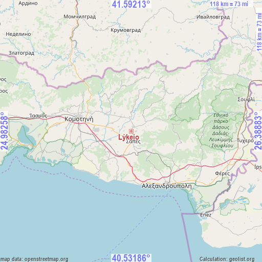
Lýkeio GPS coordinates[2]
41° 3' 50.868" North, 25° 41' 8.52" East
| Map corner | latitude | longitude |
|---|---|---|
| Upper-left | 41.59213°, | 24.98258° |
| Center: | 41.06413°, | 25.6857° |
| Lower-right: | 40.53186°, | 26.38883° |
| Map W x H: | 117.9×117.9 km | = 73.3×73.3mi |
| max Lat: | 41.72048° ⇑5.8% North |
| Lýkeio: | 41.06413° |
| min Lat: | ⇓94.2% South 34.8346° |
| min Long | Lýkeio | max Long |
| 19.40494° | 25.6857° | 29.59361° |
| W 91.6%⇐ | ⇒8.4% E |
Elevation
Elevation of Lýkeio is 56 m = 184 ft, and this is 112.9 m = 370 ft below average elevation for this country.
| Max E: |
1439 m = 4721 ft | 58.1% |
| Avg. | 168.9 m = 554 ft | |
| Lýkeio | 56 m = 184 ft | |
Min E: |
0 m = 0 ft | 41.9% |
See also: Greece elevation on elevation.city.
Geographical zone
Lýkeio is located in North temperate zone (between Tropic of Cancer and the Arctic Circle). Distance of this Northern Tropic circle is 1960 km =1217.9 mi to South.| Distance of | km | miles | from Lýkeio |
|---|---|---|---|
| North Pole | 5441.2 | 3381 | to North |
| Arctic Circle | 2835.3 | 1761.8 | to North |
| Tropic Cancer | 1960 | 1217.9 | to South |
| Equator | 4565.9 | 2837.1 | to South |


Nearby cities:
15 places around Lýkeio: (largest is in red/bold)
• Alexandroupoli
28.7 km =17.8 mi,  146°
146°
• Arrianá
2.1 km =1.3 mi,  22°
22°
• Arísvi
8 km =5 mi,  274°
274°
• Fillýra
7.3 km =4.5 mi,  323°
323°
• Féres
45.1 km =28 mi,  114°
114°
• Komotiní
24.3 km =15.1 mi,  284°
284°
• Loutrós
36.5 km =22.7 mi,  123°
123°
• Méga Pistó
33.5 km =20.8 mi,  285°
285°
• Nípsa
31.7 km =19.7 mi, 118°
• Pagoúria
31.1 km =19.3 mi,  262°
262°
• Sápes
4 km =2.5 mi,  171°
171°
• Xylaganí
24.4 km =15.2 mi,  245°
245°
• Ántheia
33.4 km =20.8 mi,  129°
129°
• Áratos
11.4 km =7.1 mi, 279°
• Íasmos
42.5 km =26.4 mi, 279°
Sources, notices
• [Note1] Compared only with cities in Greece existing in our database
• [Src1] Map data: © OpenStreetMap contributors (CC-BY-SA)
• [Src2] Other city data from geonames.org with taken over terms of usage.
• [Src3] Geographical zone / Annual Mean Temperature by Robert A. Rohde @ Wikipedia
