Gomáti geodata
Gomáti (Central Macedonia) is a populated place; located in Greece in Europe/Athens (GMT+3) time zone. With population of 509 people, there are 1789 cities with bigger population in this country. Compared to other cities in Greece, 71.9% of cities are located further ↓South; 73.1% of cities are located further ←West and 55.8% of cities have lower elevation than Gomáti. Note1
Administrative division(s):
- Level 1: Central Macedonia
- Level 2: Nomós Chalkidikís
- Level 3: Dimos Aristotelis


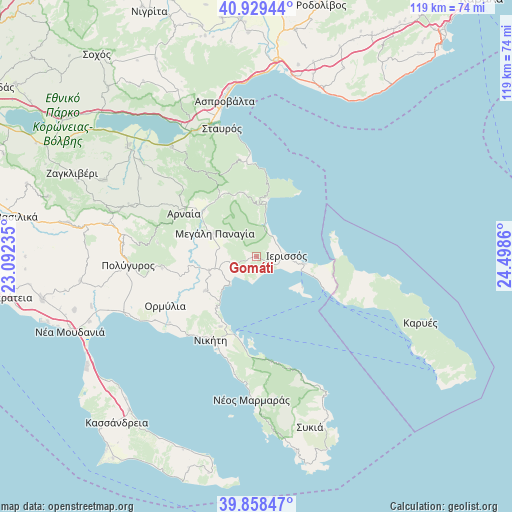
Gomáti GPS coordinates[2]
40° 23' 45.888" North, 23° 47' 43.692" East
| Map corner | latitude | longitude |
|---|---|---|
| Upper-left | 40.92944°, | 23.09235° |
| Center: | 40.39608°, | 23.79547° |
| Lower-right: | 39.85847°, | 24.4986° |
| Map W x H: | 119.1×119.1 km | = 74×74mi |
| max Lat: | 41.72048° ⇑28.1% North |
| Gomáti: | 40.39608° |
| min Lat: | ⇓71.9% South 34.8346° |
| min Long | Gomáti | max Long |
| 19.40494° | 23.79547° | 29.59361° |
| W 73.1%⇐ | ⇒26.9% E |
Elevation
Elevation of Gomáti is 101 m = 331 ft, and this is 67.9 m = 223 ft below average elevation for this country.
| Max E: |
1439 m = 4721 ft | 44.2% |
| Avg. | 168.9 m = 554 ft | |
| Gomáti | 101 m = 331 ft | |
Min E: |
0 m = 0 ft | 55.8% |
See also: Greece elevation on elevation.city.
Geographical zone
Gomáti is located in North temperate zone (between Tropic of Cancer and the Arctic Circle). Distance of this Northern Tropic circle is 1885.7 km =1171.7 mi to South.| Distance of | km | miles | from Gomáti |
|---|---|---|---|
| North Pole | 5515.4 | 3427.1 | to North |
| Arctic Circle | 2909.6 | 1807.9 | to North |
| Tropic Cancer | 1885.7 | 1171.7 | to South |
| Equator | 4491.6 | 2790.9 | to South |


Nearby cities:
15 places around Gomáti: (largest is in red/bold)
• Ammoulianí
12.8 km =8 mi,  123°
123°
• Arnaía
19.7 km =12.2 mi,  300°
300°
• Ierissós
6.7 km =4.2 mi,  88°
88°
• Megáli Panagía
11.2 km =7 mi, 299°
• Metagkítsi
14.3 km =8.9 mi,  236°
236°
• Neochóri
15.9 km =9.9 mi,  321°
321°
• Néa Róda
11 km =6.8 mi,  98°
98°
• Níkiti
22.1 km =13.7 mi,  209°
209°
• Olympiáda
21.8 km =13.5 mi,  357°
357°
• Ouranoupolis
17.4 km =10.8 mi,  113°
113°
• Palaiochóri
16.3 km =10.1 mi,  310°
310°
• Stratoníki
14.9 km =9.3 mi,  349°
349°
• Stratónion
13.3 km =8.3 mi,  10°
10°
• Vrástama
22.1 km =13.7 mi,  263°
263°
• Ágios Nikólaos
18.4 km =11.4 mi, 207°
Sources, notices
• [Note1] Compared only with cities in Greece existing in our database
• [Src1] Map data: © OpenStreetMap contributors (CC-BY-SA)
• [Src2] Other city data from geonames.org with taken over terms of usage.
• [Src3] Geographical zone / Annual Mean Temperature by Robert A. Rohde @ Wikipedia
