Féres geodata
Féres (East Macedonia and Thrace) is a populated place; located in Greece in Europe/Athens (GMT+3) time zone. With population of 5,403 people, there are 221 cities with bigger population in this country. Compared to other cities in Greece, 88.2% of cities are located further ↓South; 94.4% of cities are located further ←West and 70.8% of cities have higher elevation than Féres. Note1
Administrative division(s):
- Level 1: East Macedonia and Thrace
- Level 2: Nomós Évrou
- Level 3: Dimos Alexandroupoli


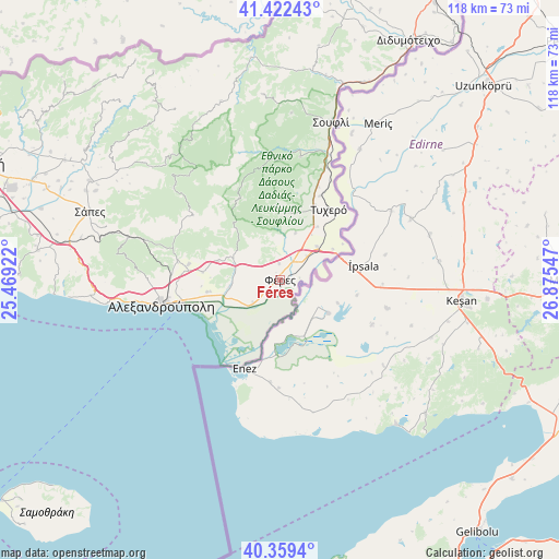
Féres GPS coordinates[2]
40° 53' 34.98" North, 26° 10' 20.424" East
| Map corner | latitude | longitude |
|---|---|---|
| Upper-left | 41.42243°, | 25.46922° |
| Center: | 40.89305°, | 26.17234° |
| Lower-right: | 40.3594°, | 26.87547° |
| Map W x H: | 118.2×118.2 km | = 73.4×73.4mi |
| max Lat: | 41.72048° ⇑11.8% North |
| Féres: | 40.89305° |
| min Lat: | ⇓88.2% South 34.8346° |
| min Long | Féres | max Long |
| 19.40494° | 26.17234° | 29.59361° |
| W 94.4%⇐ | ⇒5.6% E |
Elevation
Elevation of Féres is 30 m = 98 ft, and this is 138.9 m = 456 ft below average elevation for this country.
| Max E: |
1439 m = 4721 ft | 70.8% |
| Avg. | 168.9 m = 554 ft | |
| Féres | 30 m = 98 ft | |
Min E: |
0 m = 0 ft | 29.2% |
See also: Greece elevation on elevation.city.
Geographical zone
Féres is located in North temperate zone (between Tropic of Cancer and the Arctic Circle). Distance of this Northern Tropic circle is 1941 km =1206.1 mi to South.| Distance of | km | miles | from Féres |
|---|---|---|---|
| North Pole | 5460.2 | 3392.8 | to North |
| Arctic Circle | 2854.3 | 1773.6 | to North |
| Tropic Cancer | 1941 | 1206.1 | to South |
| Equator | 4546.9 | 2825.3 | to South |


Nearby cities:
15 places around Féres: (largest is in red/bold)
• Alexandroupoli
25.3 km =15.7 mi,  259°
259°
• Arrianá
45.2 km =28.1 mi,  297°
297°
• Arísvi
52.7 km =32.7 mi,  291°
291°
• Dadía
26.5 km =16.5 mi,  9°
9°
• Fillýra
51.6 km =32.1 mi, 298°
• Loutrós
10.6 km =6.6 mi, 263°
• Lávara
45.5 km =28.3 mi,  23°
23°
• Lýkeio
45.1 km =28 mi, 294°
• Nípsa
13.6 km =8.5 mi, 287°
• Provatónas
16.5 km =10.3 mi,  26°
26°
• Péplos
10.6 km =6.6 mi,  47°
47°
• Souflí
34.9 km =21.7 mi, 17°
• Sápes
43 km =26.7 mi, 290°
• Tycheró
18.2 km =11.3 mi, 34°
• Ántheia
15.5 km =9.6 mi, 261°
Sources, notices
• [Note1] Compared only with cities in Greece existing in our database
• [Src1] Map data: © OpenStreetMap contributors (CC-BY-SA)
• [Src2] Other city data from geonames.org with taken over terms of usage.
• [Src3] Geographical zone / Annual Mean Temperature by Robert A. Rohde @ Wikipedia
