Nípsa geodata
Nípsa (East Macedonia and Thrace) is a populated place; located in Greece in Europe/Athens (GMT+3) time zone. With population of 523 people, there are 1759 cities with bigger population in this country. Compared to other cities in Greece, 89.4% of cities are located further ↓South; 93.1% of cities are located further ←West and 71.3% of cities have lower elevation than Nípsa. Note1
Administrative division(s):
- Level 1: East Macedonia and Thrace
- Level 2: Nomós Évrou
- Level 3: Dimos Alexandroupoli


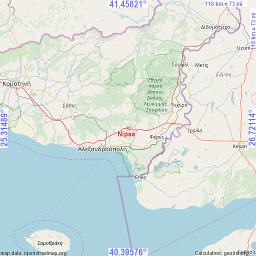
Nípsa GPS coordinates[2]
40° 55' 44.832" North, 26° 1' 4.836" East
| Map corner | latitude | longitude |
|---|---|---|
| Upper-left | 41.45821°, | 25.31489° |
| Center: | 40.92912°, | 26.01801° |
| Lower-right: | 40.39576°, | 26.72114° |
| Map W x H: | 118.1×118.1 km | = 73.4×73.4mi |
| max Lat: | 41.72048° ⇑10.6% North |
| Nípsa: | 40.92912° |
| min Lat: | ⇓89.4% South 34.8346° |
| min Long | Nípsa | max Long |
| 19.40494° | 26.01801° | 29.59361° |
| W 93.1%⇐ | ⇒6.9% E |
Elevation
Elevation of Nípsa is 176 m = 577 ft, and this is 7.1 m = 23 ft above average elevation for this country.
| Max E: |
1439 m = 4721 ft | 28.7% |
| Nípsa | 176 m 577 ft | |
| Avg. | 168.9 m = 554 ft | |
Min E: |
0 m = 0 ft | 71.3% |
See also: Greece elevation on elevation.city.
Geographical zone
Nípsa is located in North temperate zone (between Tropic of Cancer and the Arctic Circle). Distance of this Northern Tropic circle is 1945 km =1208.6 mi to South.| Distance of | km | miles | from Nípsa |
|---|---|---|---|
| North Pole | 5456.2 | 3390.3 | to North |
| Arctic Circle | 2850.3 | 1771.1 | to North |
| Tropic Cancer | 1945 | 1208.6 | to South |
| Equator | 4550.9 | 2827.8 | to South |


Nearby cities:
15 places around Nípsa: (largest is in red/bold)
• Alexandroupoli
14.8 km =9.2 mi,  233°
233°
• Arrianá
32 km =19.9 mi,  301°
301°
• Arísvi
39.2 km =24.4 mi,  293°
293°
• Dadía
28.1 km =17.5 mi,  38°
38°
• Fillýra
38.4 km =23.9 mi, 302°
• Féres
13.6 km =8.5 mi,  107°
107°
• Loutrós
5.8 km =3.6 mi,  155°
155°
• Lýkeio
31.7 km =19.7 mi, 298°
• Provatónas
23 km =14.3 mi,  61°
61°
• Péplos
21 km =13 mi,  81°
81°
• Souflí
37.6 km =23.4 mi, 38°
• Sápes
29.4 km =18.3 mi, 292°
• Tycheró
25.7 km =16 mi, 64°
• Ántheia
6.8 km =4.2 mi,  199°
199°
• Áratos
42.6 km =26.5 mi, 293°
Sources, notices
• [Note1] Compared only with cities in Greece existing in our database
• [Src1] Map data: © OpenStreetMap contributors (CC-BY-SA)
• [Src2] Other city data from geonames.org with taken over terms of usage.
• [Src3] Geographical zone / Annual Mean Temperature by Robert A. Rohde @ Wikipedia
