Alexandroupoli geodata
Alexandroupoli (East Macedonia and Thrace) is a seat of a second-order administrative division; located in Greece in Europe/Athens (GMT+3) time zone. With population of 52,979 people, there are 38 cities with bigger population in this country. Compared to other cities in Greece, 87.3% of cities are located further ↓South; 92.5% of cities are located further ←West and 78.7% of cities have higher elevation than Alexandroupoli. Note1
Administrative division(s):
- Level 1: East Macedonia and Thrace
- Level 2: Nomós Évrou
- Level 3: Dimos Alexandroupoli


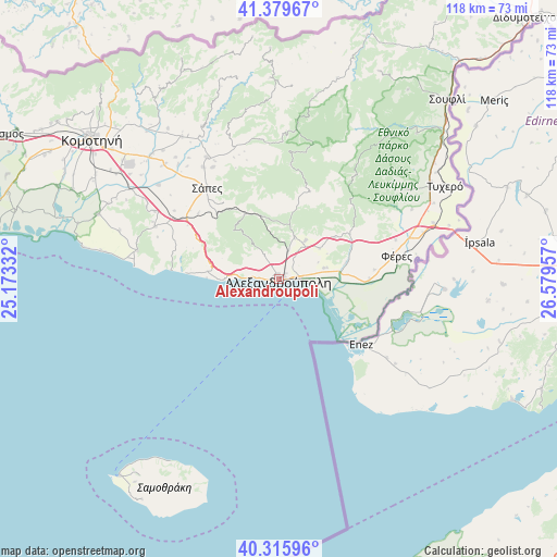
Alexandroupoli GPS coordinates[2]
40° 50' 59.82" North, 25° 52' 35.184" East
| Map corner | latitude | longitude |
|---|---|---|
| Upper-left | 41.37967°, | 25.17332° |
| Center: | 40.84995°, | 25.87644° |
| Lower-right: | 40.31596°, | 26.57957° |
| Map W x H: | 118.3×118.3 km | = 73.5×73.5mi |
| max Lat: | 41.72048° ⇑12.7% North |
| Alexandroupoli: | 40.84995° |
| min Lat: | ⇓87.3% South 34.8346° |
| min Long | Alexandroupoli | max Long |
| 19.40494° | 25.87644° | 29.59361° |
| W 92.5%⇐ | ⇒7.5% E |
Elevation
Elevation of Alexandroupoli is 19 m = 62 ft, and this is 149.9 m = 492 ft below average elevation for this country.
| Max E: |
1439 m = 4721 ft | 78.7% |
| Avg. | 168.9 m = 554 ft | |
| Alexandroupoli | 19 m = 62 ft | |
Min E: |
0 m = 0 ft | 21.3% |
See also: Alexandroupoli elevation on elevation.city.
Geographical zone
Alexandroupoli is located in North temperate zone (between Tropic of Cancer and the Arctic Circle). Distance of this Northern Tropic circle is 1936.2 km =1203.1 mi to South.| Distance of | km | miles | from Alexandroupoli |
|---|---|---|---|
| North Pole | 5465 | 3395.8 | to North |
| Arctic Circle | 2859.1 | 1776.6 | to North |
| Tropic Cancer | 1936.2 | 1203.1 | to South |
| Equator | 4542.1 | 2822.3 | to South |


Nearby cities:
15 places around Alexandroupoli: (largest is in red/bold)
• Arrianá
29.9 km =18.6 mi,  329°
329°
• Arísvi
34.3 km =21.3 mi,  315°
315°
• Dadía
42.6 km =26.5 mi,  43°
43°
• Fillýra
36 km =22.4 mi, 325°
• Féres
25.3 km =15.7 mi,  79°
79°
• Loutrós
14.8 km =9.2 mi, 76°
• Lýkeio
28.7 km =17.8 mi, 326°
• Nípsa
14.8 km =9.2 mi,  53°
53°
• Provatónas
37.7 km =23.4 mi,  58°
58°
• Péplos
34.8 km =21.6 mi,  69°
69°
• Sápes
25.1 km =15.6 mi, 322°
• Tycheró
40.4 km =25.1 mi, 60°
• Xylaganí
40.8 km =25.4 mi,  289°
289°
• Ántheia
9.9 km =6.2 mi, 76°
• Áratos
37.5 km =23.3 mi,  313°
313°
In other languages:
- In Spanish: Alejandrópolis
- In German: Alexandroupolis
- In Italian: Alessandropoli
- In Russian: Александруполис
Sources, notices
• [Note1] Compared only with cities in Greece existing in our database
• [Src1] Map data: © OpenStreetMap contributors (CC-BY-SA)
• [Src2] Other city data from geonames.org with taken over terms of usage.
• [Src3] Geographical zone / Annual Mean Temperature by Robert A. Rohde @ Wikipedia
