Ágios Athanásios geodata
Ágios Athanásios (Central Macedonia) is a populated place; located in Greece in Europe/Athens (GMT+3) time zone. With population of 4,648 people, there are 252 cities with bigger population in this country. Compared to other cities in Greece, 81.9% of cities are located further ↓South; 54.1% of cities are located further →East and 76.9% of cities have higher elevation than Ágios Athanásios. Note1
Administrative division(s):
- Level 1: Central Macedonia
- Level 2: Nomós Thessaloníkis
- Level 3: Dimos Chalkidona


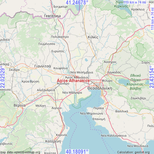
Ágios Athanásios GPS coordinates[2]
40° 42' 57.528" North, 22° 43' 42.276" East
| Map corner | latitude | longitude |
|---|---|---|
| Upper-left | 41.24678°, | 22.02529° |
| Center: | 40.71598°, | 22.72841° |
| Lower-right: | 40.18091°, | 23.43154° |
| Map W x H: | 118.5×118.5 km | = 73.6×73.6mi |
| max Lat: | 41.72048° ⇑18.1% North |
| Ágios Athanásios: | 40.71598° |
| min Lat: | ⇓81.9% South 34.8346° |
| min Long | Ágios Athanás | max Long |
| 19.40494° | 22.72841° | 29.59361° |
| W 45.9%⇐ | ⇒54.1% E |
Elevation
Elevation of Ágios Athanásios is 21 m = 69 ft, and this is 147.9 m = 485 ft below average elevation for this country.
| Max E: |
1439 m = 4721 ft | 76.9% |
| Avg. | 168.9 m = 554 ft | |
| Ágios Athanásios | 21 m = 69 ft | |
Min E: |
0 m = 0 ft | 23.1% |
See also: Greece elevation on elevation.city.
Geographical zone
Ágios Athanásios is located in North temperate zone (between Tropic of Cancer and the Arctic Circle). Distance of this Northern Tropic circle is 1921.3 km =1193.8 mi to South.| Distance of | km | miles | from Ágios Athanásios |
|---|---|---|---|
| North Pole | 5479.9 | 3405.1 | to North |
| Arctic Circle | 2874 | 1785.8 | to North |
| Tropic Cancer | 1921.3 | 1193.8 | to South |
| Equator | 4527.2 | 2813.1 | to South |


Nearby cities:
15 places around Ágios Athanásios: (largest is in red/bold)
• Anatolikó
6.2 km =3.9 mi,  192°
192°
• Anchíalos
4.4 km =2.7 mi,  91°
91°
• Chalástra
10 km =6.2 mi,  177°
177°
• Eleoúsa
9.3 km =5.8 mi,  292°
292°
• Géfyra
3.5 km =2.2 mi,  302°
302°
• Néa Magnisía
10.4 km =6.5 mi,  107°
107°
• Néa Mesimvría
5.2 km =3.2 mi,  40°
40°
• Néo Agionéri
10.4 km =6.5 mi,  350°
350°
• Parthéni
10.4 km =6.5 mi,  260°
260°
• Pentálofos
10.9 km =6.8 mi,  73°
73°
• Próchoma
10.5 km =6.5 mi,  330°
330°
• Síndos
8.2 km =5.1 mi,  127°
127°
• Vathýlakkos
6.2 km =3.9 mi,  344°
344°
• Vrachiá
9.5 km =5.9 mi,  231°
231°
• Xirochóri
10.6 km =6.6 mi,  23°
23°
Sources, notices
• [Note1] Compared only with cities in Greece existing in our database
• [Src1] Map data: © OpenStreetMap contributors (CC-BY-SA)
• [Src2] Other city data from geonames.org with taken over terms of usage.
• [Src3] Geographical zone / Annual Mean Temperature by Robert A. Rohde @ Wikipedia
