Santa Catarina Palopó geodata
Santa Catarina Palopó (Sololá) is a seat of a second-order administrative division; located in Guatemala in America/Guatemala (GMT-6) time zone. With population of 2,948 people, there are 244 cities with bigger population in this country. Compared to other cities in Guatemala, 57.2% of cities are located further ↑North; 56% of cities are located further →East and 60.8% of cities have lower elevation than Santa Catarina Palopó. Note1


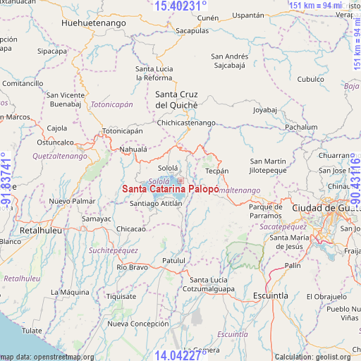
Santa Catarina Palopó GPS coordinates[2]
14° 43' 24.06" North, 91° 8' 3.408" West
| Map corner | latitude | longitude |
|---|---|---|
| Upper-left | 15.40231°, | -91.83741° |
| Center: | 14.72335°, | -91.13428° |
| Lower-right: | 14.04227°, | -90.43116° |
| Map W x H: | 151.2×151.2 km | = 94×94mi |
| max Lat: | 17.06606° ⇑57.2% North |
| Santa Catarina Palopó: | 14.72335° |
| min Lat: | ⇓42.8% South 13.9274° |
| min Long | Santa Catarina | max Long |
| -92.19298° | -91.13428° | -88.59444° |
| W 44%⇐ | ⇒56% E |
Elevation
Elevation of Santa Catarina Palopó is 1573 m = 5161 ft, and this is 306 m = 1004 ft above average elevation for this country.
| Max E: |
3254 m = 10676 ft | 39.2% |
| Santa Catarina Palopó | 1573 m 5161 ft | |
| Avg. | 1267 m = 4157 ft | |
Min E: |
1 m = 3 ft | 60.8% |
See also: Guatemala elevation on elevation.city.
Geographical zone
Santa Catarina Palopó is located in North Torrid zone (between Equator and Tropic of Cancer). Distance of this Northern Tropic circle is 968.8 km =602 mi to North.| Distance of | km | miles | from Santa Catarina Palopó |
|---|---|---|---|
| North Pole | 8370 | 5200.9 | to North |
| Arctic Circle | 5764.1 | 3581.6 | to North |
| Tropic Cancer | 968.8 | 602 | to North |
| Equator | 1637.1 | 1017.2 | to South |


Nearby cities:
15 places around Santa Catarina Palopó: (largest is in red/bold)
• Concepción
6.9 km =4.3 mi,  348°
348°
• Panajachel
3.2 km =2 mi,  310°
310°
• Patzún
13.7 km =8.5 mi,  109°
109°
• San Andrés Semetabaj
2.4 km =1.5 mi,  2°
2°
• San Antonio Palopó
4 km =2.5 mi,  150°
150°
• San José Chacayá
10.2 km =6.3 mi,  301°
301°
• San Lucas Tolimán
14.4 km =8.9 mi,  185°
185°
• San Marcos La Laguna
13.4 km =8.3 mi,  270°
270°
• San Pablo La Laguna
14.9 km =9.3 mi, 268°
• San Pedro La Laguna
15.2 km =9.4 mi,  257°
257°
• Santa Cruz La Laguna
8.2 km =5.1 mi,  286°
286°
• Santa Lucía Utatlán
15.2 km =9.4 mi, 290°
• Santiago Atitlán
13.9 km =8.6 mi,  227°
227°
• Sololá
7.6 km =4.7 mi,  315°
315°
• Tecpán Guatemala
15.8 km =9.8 mi,  74°
74°
Sources, notices
• [Note1] Compared only with cities in Guatemala existing in our database
• [Src1] Map data: © OpenStreetMap contributors (CC-BY-SA)
• [Src2] Other city data from geonames.org with taken over terms of usage.
• [Src3] Geographical zone / Annual Mean Temperature by Robert A. Rohde @ Wikipedia
