Tecpán Guatemala geodata
Tecpán Guatemala (Chimaltenango) is a seat of a second-order administrative division; located in Guatemala in America/Guatemala (GMT-6) time zone. With population of 21,978 people, there are 49 cities with bigger population in this country. Compared to other cities in Guatemala, 54.9% of cities are located further ↑North; 51.3% of cities are located further →East and 86.7% of cities have lower elevation than Tecpán Guatemala. Note1


Tecpán Guatemala GPS coordinates[2]
14° 45' 42.516" North, 90° 59' 32.892" West
| Map corner | latitude | longitude |
|---|---|---|
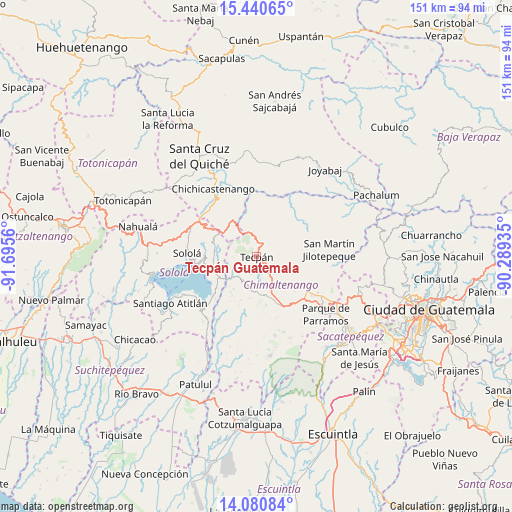
| Upper-left | 15.44065°, | -91.6956° |
| Center: | 14.76181°, | -90.99247° |
| Lower-right: | 14.08084°, | -90.28935° |
| Map W x H: | 151.2×151.2 km | = 94×94mi |
| max Lat: | 17.06606° ⇑54.9% North |
| Tecpán Guatemala: | 14.76181° |
| min Lat: | ⇓45.1% South 13.9274° |
| min Long | Tecpán Guatema | max Long |
| -92.19298° | -90.99247° | -88.59444° |
| W 48.7%⇐ | ⇒51.3% E |
Elevation
Elevation of Tecpán Guatemala is 2316 m = 7598 ft, and this is 1049 m = 3442 ft above average elevation for this country.
| Max E: |
3254 m = 10676 ft | 13.3% |
| Tecpán Guatemala | 2316 m 7598 ft | |
| Avg. | 1267 m = 4157 ft | |
Min E: |
1 m = 3 ft | 86.7% |
See also: Guatemala elevation on elevation.city.
Geographical zone
Tecpán Guatemala is located in North Torrid zone (between Equator and Tropic of Cancer). Distance of this Northern Tropic circle is 964.6 km =599.4 mi to North.| Distance of | km | miles | from Tecpán Guatemala |
|---|---|---|---|
| North Pole | 8365.7 | 5198.2 | to North |
| Arctic Circle | 5759.8 | 3579 | to North |
| Tropic Cancer | 964.6 | 599.4 | to North |
| Equator | 1641.4 | 1019.9 | to South |


Nearby cities:
15 places around Tecpán Guatemala: (largest is in red/bold)
• Chimaltenango
21.7 km =13.5 mi,  121°
121°
• Comalapa
11.5 km =7.1 mi,  101°
101°
• Concepción
16.9 km =10.5 mi,  278°
278°
• Panajachel
17.8 km =11.1 mi,  262°
262°
• Patzicía
16.1 km =10 mi,  153°
153°
• Patzún
9.2 km =5.7 mi,  194°
194°
• San Andrés Semetabaj
15.3 km =9.5 mi, 262°
• San Antonio Palopó
15.4 km =9.6 mi,  239°
239°
• San José Poaquil
10.6 km =6.6 mi,  53°
53°
• San Martín Jilotepeque
21.6 km =13.4 mi,  84°
84°
• Santa Apolonia
3.8 km =2.4 mi,  33°
33°
• Santa Catarina Palopó
15.8 km =9.8 mi,  254°
254°
• Santa Cruz Balanyá
11.6 km =7.2 mi,  137°
137°
• Sololá
20.6 km =12.8 mi,  273°
273°
• Zaragoza
16.6 km =10.3 mi, 138°
Sources, notices
• [Note1] Compared only with cities in Guatemala existing in our database
• [Src1] Map data: © OpenStreetMap contributors (CC-BY-SA)
• [Src2] Other city data from geonames.org with taken over terms of usage.
• [Src3] Geographical zone / Annual Mean Temperature by Robert A. Rohde @ Wikipedia
