San Miguel Dueñas geodata
San Miguel Dueñas (Sacatepéquez) is a seat of a second-order administrative division; located in Guatemala in America/Guatemala (GMT-6) time zone. With population of 8,424 people, there are 151 cities with bigger population in this country. Compared to other cities in Guatemala, 80.5% of cities are located further ↑North; 55.5% of cities are located further ←West and 57.2% of cities have lower elevation than San Miguel Dueñas. Note1


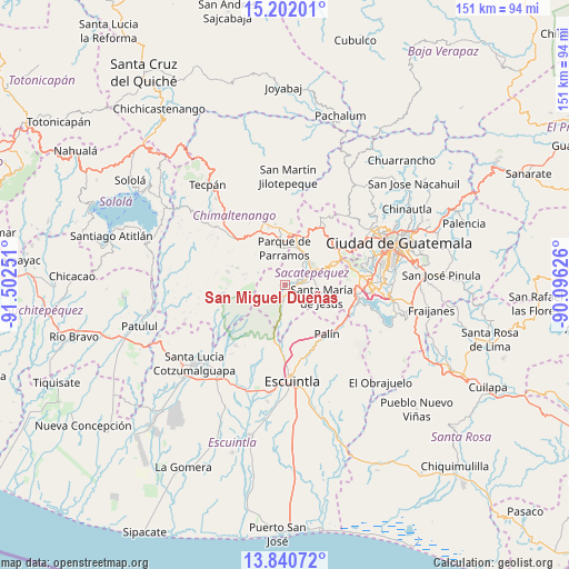
San Miguel Dueñas GPS coordinates[2]
14° 31' 20.676" North, 90° 47' 57.768" West
| Map corner | latitude | longitude |
|---|---|---|
| Upper-left | 15.20201°, | -91.50251° |
| Center: | 14.52241°, | -90.79938° |
| Lower-right: | 13.84072°, | -90.09626° |
| Map W x H: | 151.4×151.4 km | = 94.1×94.1mi |
| max Lat: | 17.06606° ⇑80.5% North |
| San Miguel Dueñas: | 14.52241° |
| min Lat: | ⇓19.5% South 13.9274° |
| min Long | San Miguel Due� | max Long |
| -92.19298° | -90.79938° | -88.59444° |
| W 55.5%⇐ | ⇒44.5% E |
Elevation
Elevation of San Miguel Dueñas is 1459 m = 4787 ft, and this is 192 m = 630 ft above average elevation for this country.
| Max E: |
3254 m = 10676 ft | 42.8% |
| San Miguel Dueñas | 1459 m 4787 ft | |
| Avg. | 1267 m = 4157 ft | |
Min E: |
1 m = 3 ft | 57.2% |
See also: Guatemala elevation on elevation.city.
Geographical zone
San Miguel Dueñas is located in North Torrid zone (between Equator and Tropic of Cancer). Distance of this Northern Tropic circle is 991.2 km =615.9 mi to North.| Distance of | km | miles | from San Miguel Dueñas |
|---|---|---|---|
| North Pole | 8392.3 | 5214.7 | to North |
| Arctic Circle | 5786.4 | 3595.5 | to North |
| Tropic Cancer | 991.2 | 615.9 | to North |
| Equator | 1614.7 | 1003.3 | to South |


Nearby cities:
15 places around San Miguel Dueñas: (largest is in red/bold)
• Alotenango
4.8 km =3 mi,  190°
190°
• Antigua Guatemala
8.2 km =5.1 mi,  58°
58°
• Chimaltenango
15.6 km =9.7 mi,  352°
352°
• Ciudad Vieja
3.9 km =2.4 mi,  87°
87°
• El Tejar
13.9 km =8.6 mi,  3°
3°
• Jocotenango
9.1 km =5.7 mi,  46°
46°
• Magdalena Milpas Altas
13.7 km =8.5 mi,  78°
78°
• Parramos
9.6 km =6 mi,  357°
357°
• Pastores
9.3 km =5.8 mi,  31°
31°
• San Andrés Itzapa
12.1 km =7.5 mi,  337°
337°
• San Antonio Aguas Calientes
3.4 km =2.1 mi,  36°
36°
• Santa Catarina Barahona
3.5 km =2.2 mi,  24°
24°
• Santa Lucía Milpas Altas
14.5 km =9 mi,  65°
65°
• Santa María de Jesús
10.1 km =6.3 mi,  107°
107°
• Sumpango
15.4 km =9.6 mi, 26°
Sources, notices
• [Note1] Compared only with cities in Guatemala existing in our database
• [Src1] Map data: © OpenStreetMap contributors (CC-BY-SA)
• [Src2] Other city data from geonames.org with taken over terms of usage.
• [Src3] Geographical zone / Annual Mean Temperature by Robert A. Rohde @ Wikipedia
