El Tejar geodata
El Tejar (Chimaltenango) is a seat of a second-order administrative division; located in Guatemala in America/Guatemala (GMT-6) time zone. With population of 15,770 people, there are 77 cities with bigger population in this country. Compared to other cities in Guatemala, 65.2% of cities are located further ↑North; 56% of cities are located further ←West and 69.3% of cities have lower elevation than El Tejar. Note1


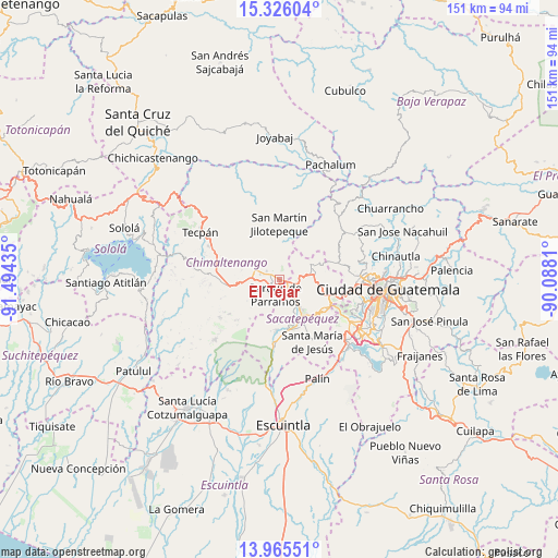
El Tejar GPS coordinates[2]
14° 38' 48.588" North, 90° 47' 28.392" West
| Map corner | latitude | longitude |
|---|---|---|
| Upper-left | 15.32604°, | -91.49435° |
| Center: | 14.64683°, | -90.79122° |
| Lower-right: | 13.96551°, | -90.0881° |
| Map W x H: | 151.3×151.3 km | = 94×94mi |
| max Lat: | 17.06606° ⇑65.2% North |
| El Tejar: | 14.64683° |
| min Lat: | ⇓34.8% South 13.9274° |
| min Long | El Tejar | max Long |
| -92.19298° | -90.79122° | -88.59444° |
| W 56%⇐ | ⇒44% E |
Elevation
Elevation of El Tejar is 1776 m = 5827 ft, and this is 509 m = 1670 ft above average elevation for this country.
| Max E: |
3254 m = 10676 ft | 30.7% |
| El Tejar | 1776 m 5827 ft | |
| Avg. | 1267 m = 4157 ft | |
Min E: |
1 m = 3 ft | 69.3% |
See also: Guatemala elevation on elevation.city.
Geographical zone
El Tejar is located in North Torrid zone (between Equator and Tropic of Cancer). Distance of this Northern Tropic circle is 977.3 km =607.3 mi to North.| Distance of | km | miles | from El Tejar |
|---|---|---|---|
| North Pole | 8378.5 | 5206.2 | to North |
| Arctic Circle | 5772.6 | 3586.9 | to North |
| Tropic Cancer | 977.3 | 607.3 | to North |
| Equator | 1628.6 | 1012 | to South |


Nearby cities:
15 places around El Tejar: (largest is in red/bold)
• Antigua Guatemala
11.3 km =7 mi,  147°
147°
• Chimaltenango
3.4 km =2.1 mi,  297°
297°
• Ciudad Vieja
14 km =8.7 mi,  167°
167°
• Jocotenango
9.5 km =5.9 mi,  143°
143°
• Parramos
4.4 km =2.7 mi,  196°
196°
• Pastores
7 km =4.3 mi, 146°
• San Andrés Itzapa
6.2 km =3.9 mi,  243°
243°
• San Antonio Aguas Calientes
11.2 km =7 mi, 174°
• San Bartolomé Milpas Altas
13 km =8.1 mi,  110°
110°
• San Miguel Dueñas
13.9 km =8.6 mi,  183°
183°
• Santa Catarina Barahona
10.6 km =6.6 mi, 176°
• Santiago Sacatepéquez
12.4 km =7.7 mi,  96°
96°
• Santo Domingo Xenacoj
10.5 km =6.5 mi,  69°
69°
• Sumpango
6.1 km =3.8 mi,  90°
90°
• Zaragoza
10.7 km =6.6 mi,  271°
271°
Sources, notices
• [Note1] Compared only with cities in Guatemala existing in our database
• [Src1] Map data: © OpenStreetMap contributors (CC-BY-SA)
• [Src2] Other city data from geonames.org with taken over terms of usage.
• [Src3] Geographical zone / Annual Mean Temperature by Robert A. Rohde @ Wikipedia
