San Andrés Itzapa geodata
San Andrés Itzapa (Chimaltenango) is a seat of a second-order administrative division; located in Guatemala in America/Guatemala (GMT-6) time zone. With population of 18,647 people, there are 64 cities with bigger population in this country. Compared to other cities in Guatemala, 68.7% of cities are located further ↑North; 53.4% of cities are located further ←West and 71.7% of cities have lower elevation than San Andrés Itzapa. Note1


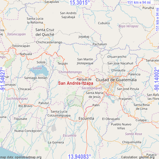
San Andrés Itzapa GPS coordinates[2]
14° 37' 19.992" North, 90° 50' 35.304" West
| Map corner | latitude | longitude |
|---|---|---|
| Upper-left | 15.3015°, | -91.54627° |
| Center: | 14.62222°, | -90.84314° |
| Lower-right: | 13.94083°, | -90.14002° |
| Map W x H: | 151.3×151.3 km | = 94×94mi |
| max Lat: | 17.06606° ⇑68.7% North |
| San Andrés Itzapa: | 14.62222° |
| min Lat: | ⇓31.3% South 13.9274° |
| min Long | San Andrés Itz | max Long |
| -92.19298° | -90.84314° | -88.59444° |
| W 53.4%⇐ | ⇒46.6% E |
Elevation
Elevation of San Andrés Itzapa is 1858 m = 6096 ft, and this is 591 m = 1939 ft above average elevation for this country.
| Max E: |
3254 m = 10676 ft | 28.3% |
| San Andrés Itzapa | 1858 m 6096 ft | |
| Avg. | 1267 m = 4157 ft | |
Min E: |
1 m = 3 ft | 71.7% |
See also: Guatemala elevation on elevation.city.
Geographical zone
San Andrés Itzapa is located in North Torrid zone (between Equator and Tropic of Cancer). Distance of this Northern Tropic circle is 980.1 km =609 mi to North.| Distance of | km | miles | from San Andrés Itzapa |
|---|---|---|---|
| North Pole | 8381.2 | 5207.8 | to North |
| Arctic Circle | 5775.3 | 3588.6 | to North |
| Tropic Cancer | 980.1 | 609 | to North |
| Equator | 1625.8 | 1010.2 | to South |


Nearby cities:
15 places around San Andrés Itzapa: (largest is in red/bold)
• Acatenango
13.2 km =8.2 mi,  235°
235°
• Antigua Guatemala
13.5 km =8.4 mi,  120°
120°
• Chimaltenango
5 km =3.1 mi,  30°
30°
• Ciudad Vieja
13.9 km =8.6 mi,  141°
141°
• El Tejar
6.2 km =3.9 mi,  63°
63°
• Jocotenango
12.3 km =7.6 mi,  113°
113°
• Parramos
4.6 km =2.9 mi, 108°
• Pastores
10 km =6.2 mi, 108°
• Patzicía
9 km =5.6 mi,  276°
276°
• San Antonio Aguas Calientes
10.8 km =6.7 mi, 141°
• San Miguel Dueñas
12.1 km =7.5 mi,  157°
157°
• Santa Catarina Barahona
10 km =6.2 mi, 142°
• Santa Cruz Balanyá
10.8 km =6.7 mi,  310°
310°
• Sumpango
12 km =7.5 mi,  77°
77°
• Zaragoza
5.9 km =3.7 mi,  301°
301°
Sources, notices
• [Note1] Compared only with cities in Guatemala existing in our database
• [Src1] Map data: © OpenStreetMap contributors (CC-BY-SA)
• [Src2] Other city data from geonames.org with taken over terms of usage.
• [Src3] Geographical zone / Annual Mean Temperature by Robert A. Rohde @ Wikipedia
