Antigua Guatemala geodata
Antigua Guatemala (Sacatepéquez) is a seat of a first-order administrative division; located in Guatemala in America/Guatemala (GMT-6) time zone. With population of 39,368 people, there are 28 cities with bigger population in this country. Compared to other cities in Guatemala, 75.5% of cities are located further ↑North; 58.1% of cities are located further ←West and 59.9% of cities have lower elevation than Antigua Guatemala. Note1


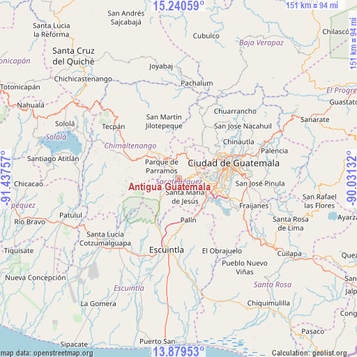
Antigua Guatemala GPS coordinates[2]
14° 33' 39.996" North, 90° 44' 3.984" West
| Map corner | latitude | longitude |
|---|---|---|
| Upper-left | 15.24059°, | -91.43757° |
| Center: | 14.56111°, | -90.73444° |
| Lower-right: | 13.87953°, | -90.03132° |
| Map W x H: | 151.3×151.3 km | = 94×94mi |
| max Lat: | 17.06606° ⇑75.5% North |
| Antigua Guatemala: | 14.56111° |
| min Lat: | ⇓24.5% South 13.9274° |
| min Long | Antigua Guatema | max Long |
| -92.19298° | -90.73444° | -88.59444° |
| W 58.1%⇐ | ⇒41.9% E |
Elevation
Elevation of Antigua Guatemala is 1539 m = 5049 ft, and this is 272 m = 892 ft above average elevation for this country.
| Max E: |
3254 m = 10676 ft | 40.1% |
| Antigua Guatemala | 1539 m 5049 ft | |
| Avg. | 1267 m = 4157 ft | |
Min E: |
1 m = 3 ft | 59.9% |
See also: Guatemala elevation on elevation.city.
Geographical zone
Antigua Guatemala is located in North Torrid zone (between Equator and Tropic of Cancer). Distance of this Northern Tropic circle is 986.9 km =613.2 mi to North.| Distance of | km | miles | from Antigua Guatemala |
|---|---|---|---|
| North Pole | 8388 | 5212.1 | to North |
| Arctic Circle | 5782.1 | 3592.8 | to North |
| Tropic Cancer | 986.9 | 613.2 | to North |
| Equator | 1619 | 1006 | to South |


Nearby cities:
15 places around Antigua Guatemala: (largest is in red/bold)
• Ciudad Vieja
5.2 km =3.2 mi,  216°
216°
• El Tejar
11.3 km =7 mi,  327°
327°
• Jocotenango
1.9 km =1.2 mi,  348°
348°
• Magdalena Milpas Altas
6.6 km =4.1 mi,  102°
102°
• Parramos
9.1 km =5.7 mi,  305°
305°
• Pastores
4.3 km =2.7 mi, 329°
• San Antonio Aguas Calientes
5.2 km =3.2 mi,  252°
252°
• San Bartolomé Milpas Altas
7.9 km =4.9 mi,  49°
49°
• San Lucas Sacatepéquez
10 km =6.2 mi,  56°
56°
• San Miguel Dueñas
8.2 km =5.1 mi,  238°
238°
• Santa Catarina Barahona
5.7 km =3.5 mi,  258°
258°
• Santa Lucía Milpas Altas
6.5 km =4 mi,  74°
74°
• Santa María de Jesús
7.8 km =4.8 mi,  160°
160°
• Santiago Sacatepéquez
10.3 km =6.4 mi,  37°
37°
• Sumpango
9.5 km =5.9 mi,  0°
0°
Sources, notices
• [Note1] Compared only with cities in Guatemala existing in our database
• [Src1] Map data: © OpenStreetMap contributors (CC-BY-SA)
• [Src2] Other city data from geonames.org with taken over terms of usage.
• [Src3] Geographical zone / Annual Mean Temperature by Robert A. Rohde @ Wikipedia
