San Gabriel geodata
San Gabriel (Suchitepeque) is a seat of a second-order administrative division; located in Guatemala in America/Guatemala (GMT-6) time zone. With population of 4,118 people, there are 221 cities with bigger population in this country. Compared to other cities in Guatemala, 81.4% of cities are located further ↑North; 73.5% of cities are located further →East and 84.1% of cities have higher elevation than San Gabriel. Note1


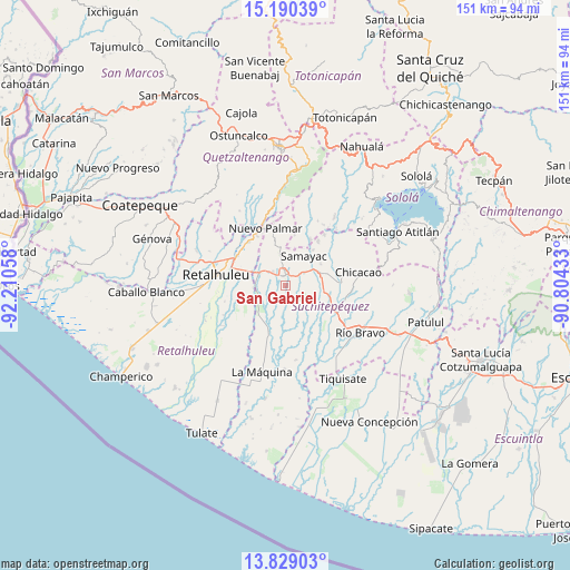
San Gabriel GPS coordinates[2]
14° 30' 38.736" North, 91° 30' 26.82" West
| Map corner | latitude | longitude |
|---|---|---|
| Upper-left | 15.19039°, | -92.21058° |
| Center: | 14.51076°, | -91.50745° |
| Lower-right: | 13.82903°, | -90.80433° |
| Map W x H: | 151.4×151.4 km | = 94.1×94.1mi |
| max Lat: | 17.06606° ⇑81.4% North |
| San Gabriel: | 14.51076° |
| min Lat: | ⇓18.6% South 13.9274° |
| min Long | San Gabriel | max Long |
| -92.19298° | -91.50745° | -88.59444° |
| W 26.5%⇐ | ⇒73.5% E |
Elevation
Elevation of San Gabriel is 285 m = 935 ft, and this is 982 m = 3222 ft below average elevation for this country.
| Max E: |
3254 m = 10676 ft | 84.1% |
| Avg. | 1267 m = 4157 ft | |
| San Gabriel | 285 m = 935 ft | |
Min E: |
1 m = 3 ft | 15.9% |
See also: Guatemala elevation on elevation.city.
Geographical zone
San Gabriel is located in North Torrid zone (between Equator and Tropic of Cancer). Distance of this Northern Tropic circle is 992.5 km =616.7 mi to North.| Distance of | km | miles | from San Gabriel |
|---|---|---|---|
| North Pole | 8393.6 | 5215.5 | to North |
| Arctic Circle | 5787.7 | 3596.3 | to North |
| Tropic Cancer | 992.5 | 616.7 | to North |
| Equator | 1613.4 | 1002.5 | to South |


Nearby cities:
15 places around San Gabriel: (largest is in red/bold)
• Cuyotenango
7.7 km =4.8 mi,  295°
295°
• Mazatenango
2.6 km =1.6 mi,  9°
9°
• Samayac
9.2 km =5.7 mi,  32°
32°
• San Andrés Villa Seca
11.2 km =7 mi,  311°
311°
• San Antonio Suchitepéquez
10.5 km =6.5 mi,  72°
72°
• San Bernardino
6.4 km =4 mi,  56°
56°
• San Francisco Zapotitlán
8.9 km =5.5 mi,  350°
350°
• San José El Ídolo
11.4 km =7.1 mi,  126°
126°
• San Lorenzo
2.8 km =1.7 mi,  191°
191°
• San Martín Zapotitlán
15.2 km =9.4 mi,  315°
315°
• San Miguel Panán
15.2 km =9.4 mi,  82°
82°
• San Pablo Jocopilas
10.5 km =6.5 mi, 34°
• Santa Cruz Muluá
14.8 km =9.2 mi, 302°
• Santo Domingo Suchitepéquez
4.4 km =2.7 mi,  143°
143°
• Zunilito
11.3 km =7 mi,  358°
358°
Sources, notices
• [Note1] Compared only with cities in Guatemala existing in our database
• [Src1] Map data: © OpenStreetMap contributors (CC-BY-SA)
• [Src2] Other city data from geonames.org with taken over terms of usage.
• [Src3] Geographical zone / Annual Mean Temperature by Robert A. Rohde @ Wikipedia
