Mazatenango geodata
Mazatenango (Suchitepeque) is a seat of a first-order administrative division; located in Guatemala in America/Guatemala (GMT-6) time zone. With population of 44,132 people, there are 24 cities with bigger population in this country. Compared to other cities in Guatemala, 79.1% of cities are located further ↑North; 73.2% of cities are located further →East and 79.6% of cities have higher elevation than Mazatenango. Note1


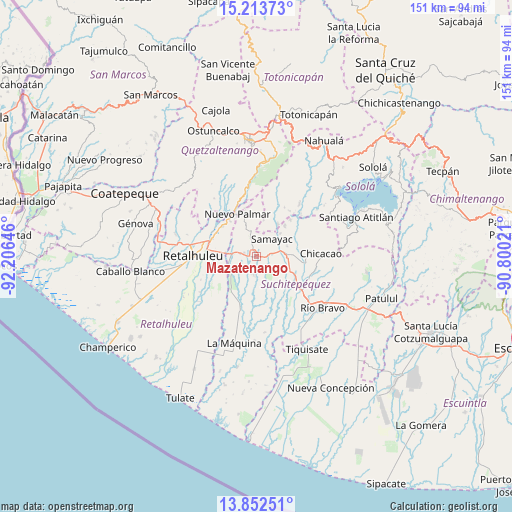
Mazatenango GPS coordinates[2]
14° 32' 3.012" North, 91° 30' 11.988" West
| Map corner | latitude | longitude |
|---|---|---|
| Upper-left | 15.21373°, | -92.20646° |
| Center: | 14.53417°, | -91.50333° |
| Lower-right: | 13.85251°, | -90.80021° |
| Map W x H: | 151.4×151.4 km | = 94.1×94.1mi |
| max Lat: | 17.06606° ⇑79.1% North |
| Mazatenango: | 14.53417° |
| min Lat: | ⇓20.9% South 13.9274° |
| min Long | Mazatenango | max Long |
| -92.19298° | -91.50333° | -88.59444° |
| W 26.8%⇐ | ⇒73.2% E |
Elevation
Elevation of Mazatenango is 373 m = 1224 ft, and this is 894 m = 2933 ft below average elevation for this country.
| Max E: |
3254 m = 10676 ft | 79.6% |
| Avg. | 1267 m = 4157 ft | |
| Mazatenango | 373 m = 1224 ft | |
Min E: |
1 m = 3 ft | 20.4% |
See also: Mazatenango elevation on elevation.city.
Geographical zone
Mazatenango is located in North Torrid zone (between Equator and Tropic of Cancer). Distance of this Northern Tropic circle is 989.9 km =615.1 mi to North.| Distance of | km | miles | from Mazatenango |
|---|---|---|---|
| North Pole | 8391 | 5213.9 | to North |
| Arctic Circle | 5785.1 | 3594.7 | to North |
| Tropic Cancer | 989.9 | 615.1 | to North |
| Equator | 1616 | 1004.1 | to South |


Nearby cities:
15 places around Mazatenango: (largest is in red/bold)
• Cuyotenango
7.4 km =4.6 mi,  275°
275°
• Pueblo Nuevo
13.1 km =8.1 mi,  342°
342°
• Samayac
6.9 km =4.3 mi,  41°
41°
• San Andrés Villa Seca
10.1 km =6.3 mi,  298°
298°
• San Antonio Suchitepéquez
9.6 km =6 mi,  86°
86°
• San Bernardino
5 km =3.1 mi,  79°
79°
• San Felipe
14 km =8.7 mi,  315°
315°
• San Francisco Zapotitlán
6.4 km =4 mi, 342°
• San Gabriel
2.6 km =1.6 mi,  189°
189°
• San José El Ídolo
12.8 km =8 mi,  136°
136°
• San Lorenzo
5.4 km =3.4 mi, 190°
• San Martín Zapotitlán
13.8 km =8.6 mi,  306°
306°
• San Pablo Jocopilas
8.2 km =5.1 mi, 42°
• Santo Domingo Suchitepéquez
6.5 km =4 mi,  160°
160°
• Zunilito
8.8 km =5.5 mi,  355°
355°
Sources, notices
• [Note1] Compared only with cities in Guatemala existing in our database
• [Src1] Map data: © OpenStreetMap contributors (CC-BY-SA)
• [Src2] Other city data from geonames.org with taken over terms of usage.
• [Src3] Geographical zone / Annual Mean Temperature by Robert A. Rohde @ Wikipedia
