San Andrés Villa Seca geodata
San Andrés Villa Seca (Retalhuleu) is a seat of a second-order administrative division; located in Guatemala in America/Guatemala (GMT-6) time zone. With population of 5,102 people, there are 202 cities with bigger population in this country. Compared to other cities in Guatemala, 74% of cities are located further ↑North; 77.9% of cities are located further →East and 75.2% of cities have higher elevation than San Andrés Villa Seca. Note1


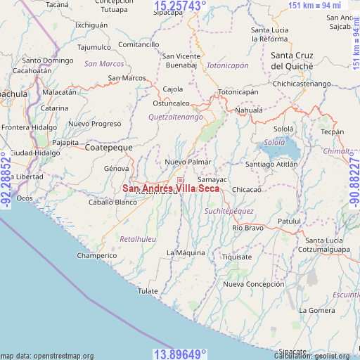
San Andrés Villa Seca GPS coordinates[2]
14° 34' 40.836" North, 91° 35' 7.404" West
| Map corner | latitude | longitude |
|---|---|---|
| Upper-left | 15.25743°, | -92.28852° |
| Center: | 14.57801°, | -91.58539° |
| Lower-right: | 13.89649°, | -90.88227° |
| Map W x H: | 151.3×151.3 km | = 94×94mi |
| max Lat: | 17.06606° ⇑74% North |
| San Andrés Villa Seca: | 14.57801° |
| min Lat: | ⇓26% South 13.9274° |
| min Long | San Andrés Vil | max Long |
| -92.19298° | -91.58539° | -88.59444° |
| W 22.1%⇐ | ⇒77.9% E |
Elevation
Elevation of San Andrés Villa Seca is 453 m = 1486 ft, and this is 814 m = 2671 ft below average elevation for this country.
| Max E: |
3254 m = 10676 ft | 75.2% |
| Avg. | 1267 m = 4157 ft | |
| San Andrés Villa Seca | 453 m = 1486 ft | |
Min E: |
1 m = 3 ft | 24.8% |
See also: Guatemala elevation on elevation.city.
Geographical zone
San Andrés Villa Seca is located in North Torrid zone (between Equator and Tropic of Cancer). Distance of this Northern Tropic circle is 985 km =612.1 mi to North.| Distance of | km | miles | from San Andrés Villa Seca |
|---|---|---|---|
| North Pole | 8386.1 | 5210.9 | to North |
| Arctic Circle | 5780.3 | 3591.7 | to North |
| Tropic Cancer | 985 | 612.1 | to North |
| Equator | 1620.9 | 1007.2 | to South |


Nearby cities:
15 places around San Andrés Villa Seca: (largest is in red/bold)
• Cuyotenango
4.5 km =2.8 mi,  160°
160°
• El Palmar
8.1 km =5 mi,  5°
5°
• Mazatenango
10.1 km =6.3 mi,  118°
118°
• Nuevo San Carlos
11.8 km =7.3 mi,  278°
278°
• Pueblo Nuevo
9.1 km =5.7 mi,  32°
32°
• Retalhuleu
11 km =6.8 mi,  244°
244°
• Samayac
13.4 km =8.3 mi,  88°
88°
• San Felipe
5.1 km =3.2 mi,  348°
348°
• San Francisco Zapotitlán
7 km =4.3 mi,  79°
79°
• San Gabriel
11.2 km =7 mi,  131°
131°
• San Lorenzo
12.9 km =8 mi,  142°
142°
• San Martín Zapotitlán
4 km =2.5 mi,  326°
326°
• San Sebastián
7 km =4.3 mi,  255°
255°
• Santa Cruz Muluá
4.2 km =2.6 mi, 275°
• Zunilito
9 km =5.6 mi,  64°
64°
Sources, notices
• [Note1] Compared only with cities in Guatemala existing in our database
• [Src1] Map data: © OpenStreetMap contributors (CC-BY-SA)
• [Src2] Other city data from geonames.org with taken over terms of usage.
• [Src3] Geographical zone / Annual Mean Temperature by Robert A. Rohde @ Wikipedia
