San Antonio Suchitepéquez geodata
San Antonio Suchitepéquez (Suchitepeque) is a seat of a second-order administrative division; located in Guatemala in America/Guatemala (GMT-6) time zone. With population of 10,951 people, there are 114 cities with bigger population in this country. Compared to other cities in Guatemala, 78.5% of cities are located further ↑North; 67% of cities are located further →East and 78.5% of cities have higher elevation than San Antonio Suchitepéquez. Note1
Current local time in San Antonio Suchitepéquez:
03:47 PM, SundayDifference from your time zone: hours


San Antonio Suchitepéquez GPS coordinates[2]
14° 32' 21.768" North, 91° 24' 51.912" West
| Map corner | latitude | longitude |
|---|---|---|
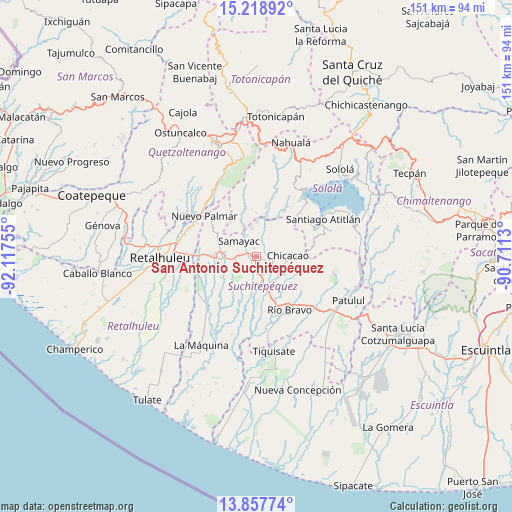
| Upper-left | 15.21892°, | -92.11755° |
| Center: | 14.53938°, | -91.41442° |
| Lower-right: | 13.85774°, | -90.7113° |
| Map W x H: | 151.3×151.4 km | = 94×94.1mi |
| max Lat: | 17.06606° ⇑78.5% North |
| San Antonio Suchitepéquez: | 14.53938° |
| min Lat: | ⇓21.5% South 13.9274° |
| min Long | San Antonio Suc | max Long |
| -92.19298° | -91.41442° | -88.59444° |
| W 33%⇐ | ⇒67% E |
Elevation
Elevation of San Antonio Suchitepéquez is 389 m = 1276 ft, and this is 878 m = 2881 ft below average elevation for this country.
| Max E: |
3254 m = 10676 ft | 78.5% |
| Avg. | 1267 m = 4157 ft | |
| San Antonio Suchitepéquez | 389 m = 1276 ft | |
Min E: |
1 m = 3 ft | 21.5% |
See also: Guatemala elevation on elevation.city.
Geographical zone
San Antonio Suchitepéquez is located in North Torrid zone (between Equator and Tropic of Cancer). Distance of this Northern Tropic circle is 989.3 km =614.7 mi to North.| Distance of | km | miles | from San Antonio Suchitepéquez |
|---|---|---|---|
| North Pole | 8390.4 | 5213.6 | to North |
| Arctic Circle | 5784.5 | 3594.3 | to North |
| Tropic Cancer | 989.3 | 614.7 | to North |
| Equator | 1616.6 | 1004.5 | to South |


Nearby cities:
15 places around San Antonio Suchitepéquez: (largest is in red/bold)
• Chicacao
9.5 km =5.9 mi,  87°
87°
• Cuyotenango
16.9 km =10.5 mi,  270°
270°
• Mazatenango
9.6 km =6 mi, 266°
• Pueblo Nuevo
18 km =11.2 mi,  311°
311°
• Samayac
6.8 km =4.2 mi, 312°
• San Bernardino
4.7 km =2.9 mi, 274°
• San Francisco Zapotitlán
12.8 km =8 mi,  295°
295°
• San Gabriel
10.5 km =6.5 mi,  252°
252°
• San José El Ídolo
10 km =6.2 mi,  184°
184°
• San Lorenzo
12.1 km =7.5 mi,  240°
240°
• San Miguel Panán
5.2 km =3.2 mi,  103°
103°
• San Pablo Jocopilas
6.8 km =4.2 mi,  323°
323°
• Santo Domingo Suchitepéquez
10 km =6.2 mi,  227°
227°
• Santo Tomás La Unión
10.3 km =6.4 mi,  2°
2°
• Zunilito
13.1 km =8.1 mi, 308°
Sources, notices
• [Note1] Compared only with cities in Guatemala existing in our database
• [Src1] Map data: © OpenStreetMap contributors (CC-BY-SA)
• [Src2] Other city data from geonames.org with taken over terms of usage.
• [Src3] Geographical zone / Annual Mean Temperature by Robert A. Rohde @ Wikipedia
