San Diego geodata
San Diego (Zacapa) is a seat of a second-order administrative division; located in Guatemala in America/Guatemala (GMT-6) time zone. With population of 557 people, there are 323 cities with bigger population in this country. Compared to other cities in Guatemala, 51.9% of cities are located further ↑North; 88.2% of cities are located further ←West and 68.1% of cities have higher elevation than San Diego. Note1


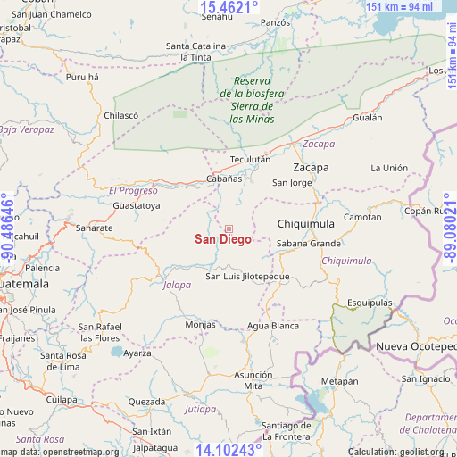
San Diego GPS coordinates[2]
14° 46' 59.988" North, 89° 46' 59.988" West
| Map corner | latitude | longitude |
|---|---|---|
| Upper-left | 15.4621°, | -90.48646° |
| Center: | 14.78333°, | -89.78333° |
| Lower-right: | 14.10243°, | -89.08021° |
| Map W x H: | 151.2×151.2 km | = 94×94mi |
| max Lat: | 17.06606° ⇑51.9% North |
| San Diego: | 14.78333° |
| min Lat: | ⇓48.1% South 13.9274° |
| min Long | San Diego | max Long |
| -92.19298° | -89.78333° | -88.59444° |
| W 88.2%⇐ | ⇒11.8% E |
Elevation
Elevation of San Diego is 705 m = 2313 ft, and this is 562 m = 1844 ft below average elevation for this country.
| Max E: |
3254 m = 10676 ft | 68.1% |
| Avg. | 1267 m = 4157 ft | |
| San Diego | 705 m = 2313 ft | |
Min E: |
1 m = 3 ft | 31.9% |
See also: Guatemala elevation on elevation.city.
Geographical zone
San Diego is located in North Torrid zone (between Equator and Tropic of Cancer). Distance of this Northern Tropic circle is 962.2 km =597.9 mi to North.| Distance of | km | miles | from San Diego |
|---|---|---|---|
| North Pole | 8363.3 | 5196.7 | to North |
| Arctic Circle | 5757.4 | 3577.5 | to North |
| Tropic Cancer | 962.2 | 597.9 | to North |
| Equator | 1643.8 | 1021.4 | to South |


Nearby cities:
15 places around San Diego: (largest is in red/bold)
• Cabañas
16.8 km =10.4 mi,  353°
353°
• Chiquimula
25.6 km =15.9 mi,  85°
85°
• El Jícaro
19.4 km =12.1 mi,  319°
319°
• Huité
18.2 km =11.3 mi,  23°
23°
• Ipala
25.8 km =16 mi,  135°
135°
• Jalapa
27.6 km =17.1 mi,  233°
233°
• San Agustín Acasaguastlán
27 km =16.8 mi,  313°
313°
• San Cristóbal Acasaguastlán
18.3 km =11.4 mi, 324°
• San Jorge
27.2 km =16.9 mi,  52°
52°
• San José La Arada
22.7 km =14.1 mi,  109°
109°
• San Luis Jilotepeque
15.8 km =9.8 mi,  160°
160°
• San Manuel Chaparrón
29.7 km =18.5 mi,  176°
176°
• San Pedro Pinula
14.8 km =9.2 mi,  208°
208°
• Teculután
23.4 km =14.5 mi, 17°
• Usumatlán
18.5 km =11.5 mi,  0°
0°
Sources, notices
• [Note1] Compared only with cities in Guatemala existing in our database
• [Src1] Map data: © OpenStreetMap contributors (CC-BY-SA)
• [Src2] Other city data from geonames.org with taken over terms of usage.
• [Src3] Geographical zone / Annual Mean Temperature by Robert A. Rohde @ Wikipedia
