Jalapa geodata
Jalapa is a seat of a first-order administrative division; located in Guatemala in America/Guatemala (GMT-6) time zone. With population of 45,834 people, there are 21 cities with bigger population in this country. Compared to other cities in Guatemala, 67% of cities are located further ↑North; 81.4% of cities are located further ←West and 54.6% of cities have lower elevation than Jalapa. Note1


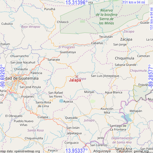
Jalapa GPS coordinates[2]
14° 38' 4.992" North, 89° 59' 20.004" West
| Map corner | latitude | longitude |
|---|---|---|
| Upper-left | 15.31396°, | -90.69202° |
| Center: | 14.63472°, | -89.98889° |
| Lower-right: | 13.95337°, | -89.28577° |
| Map W x H: | 151.3×151.3 km | = 94×94mi |
| max Lat: | 17.06606° ⇑67% North |
| Jalapa: | 14.63472° |
| min Lat: | ⇓33% South 13.9274° |
| min Long | Jalapa | max Long |
| -92.19298° | -89.98889° | -88.59444° |
| W 81.4%⇐ | ⇒18.6% E |
Elevation
Elevation of Jalapa is 1373 m = 4505 ft, and this is 106 m = 348 ft above average elevation for this country.
| Max E: |
3254 m = 10676 ft | 45.4% |
| Jalapa | 1373 m 4505 ft | |
| Avg. | 1267 m = 4157 ft | |
Min E: |
1 m = 3 ft | 54.6% |
See also: Jalapa elevation on elevation.city.
Geographical zone
Jalapa is located in North Torrid zone (between Equator and Tropic of Cancer). Distance of this Northern Tropic circle is 978.7 km =608.1 mi to North.| Distance of | km | miles | from Jalapa |
|---|---|---|---|
| North Pole | 8379.8 | 5207 | to North |
| Arctic Circle | 5773.9 | 3587.7 | to North |
| Tropic Cancer | 978.7 | 608.1 | to North |
| Equator | 1627.2 | 1011.1 | to South |


Nearby cities:
15 places around Jalapa: (largest is in red/bold)
• El Jícaro
32.8 km =20.4 mi,  16°
16°
• Guastatoya
25.9 km =16.1 mi,  340°
340°
• Mataquescuintla
24.1 km =15 mi,  240°
240°
• Monjas
19.9 km =12.4 mi,  138°
138°
• San Antonio La Paz
34.7 km =21.6 mi,  293°
293°
• San Carlos Alzatate
17.1 km =10.6 mi,  206°
206°
• San Cristóbal Acasaguastlán
33.3 km =20.7 mi, 19°
• San Diego
27.6 km =17.1 mi,  53°
53°
• San Luis Jilotepeque
27.5 km =17.1 mi,  86°
86°
• San Manuel Chaparrón
27.3 km =17 mi,  118°
118°
• San Pedro Pinula
15.4 km =9.6 mi,  76°
76°
• San Rafael Las Flores
27 km =16.8 mi,  229°
229°
• Sanarate
28.3 km =17.6 mi,  307°
307°
• Sansare
18.4 km =11.4 mi, 312°
• Santa Catarina Mita
32.9 km =20.4 mi,  128°
128°
Sources, notices
• [Note1] Compared only with cities in Guatemala existing in our database
• [Src1] Map data: © OpenStreetMap contributors (CC-BY-SA)
• [Src2] Other city data from geonames.org with taken over terms of usage.
• [Src3] Geographical zone / Annual Mean Temperature by Robert A. Rohde @ Wikipedia
