San José La Arada geodata
San José La Arada (Chiquimula) is a seat of a second-order administrative division; located in Guatemala in America/Guatemala (GMT-6) time zone. With population of 2,361 people, there are 266 cities with bigger population in this country. Compared to other cities in Guatemala, 58.7% of cities are located further ↑North; 92.9% of cities are located further ←West and 75.8% of cities have higher elevation than San José La Arada. Note1


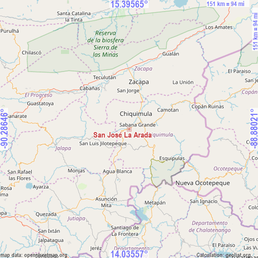
San José La Arada GPS coordinates[2]
14° 43' 0.012" North, 89° 34' 59.988" West
| Map corner | latitude | longitude |
|---|---|---|
| Upper-left | 15.39565°, | -90.28646° |
| Center: | 14.71667°, | -89.58333° |
| Lower-right: | 14.03557°, | -88.88021° |
| Map W x H: | 151.2×151.2 km | = 94×94mi |
| max Lat: | 17.06606° ⇑58.7% North |
| San José La Arada: | 14.71667° |
| min Lat: | ⇓41.3% South 13.9274° |
| min Long | San José La Ar | max Long |
| -92.19298° | -89.58333° | -88.59444° |
| W 92.9%⇐ | ⇒7.1% E |
Elevation
Elevation of San José La Arada is 442 m = 1450 ft, and this is 825 m = 2707 ft below average elevation for this country.
| Max E: |
3254 m = 10676 ft | 75.8% |
| Avg. | 1267 m = 4157 ft | |
| San José La Arada | 442 m = 1450 ft | |
Min E: |
1 m = 3 ft | 24.2% |
See also: Guatemala elevation on elevation.city.
Geographical zone
San José La Arada is located in North Torrid zone (between Equator and Tropic of Cancer). Distance of this Northern Tropic circle is 969.6 km =602.5 mi to North.| Distance of | km | miles | from San José La Arada |
|---|---|---|---|
| North Pole | 8370.7 | 5201.3 | to North |
| Arctic Circle | 5764.8 | 3582.1 | to North |
| Tropic Cancer | 969.6 | 602.5 | to North |
| Equator | 1636.3 | 1016.7 | to South |


Nearby cities:
15 places around San José La Arada: (largest is in red/bold)
• Agua Blanca
25.1 km =15.6 mi,  196°
196°
• Camotán
25.4 km =15.8 mi,  63°
63°
• Chiquimula
10.1 km =6.3 mi,  23°
23°
• Concepción Las Minas
25.6 km =15.9 mi,  147°
147°
• Huité
28 km =17.4 mi,  329°
329°
• Ipala
11.7 km =7.3 mi, 197°
• Jocotán
23.8 km =14.8 mi, 60°
• Olopa
25.2 km =15.7 mi,  96°
96°
• Quezaltepeque
17.6 km =10.9 mi,  120°
120°
• San Diego
22.7 km =14.1 mi,  289°
289°
• San Jacinto
10.5 km =6.5 mi, 121°
• San Jorge
24.1 km =15 mi,  0°
0°
• San Juan Ermita
17.3 km =10.7 mi,  72°
72°
• San Luis Jilotepeque
17.8 km =11.1 mi,  245°
245°
• Zacapa
29 km =18 mi,  11°
11°
Sources, notices
• [Note1] Compared only with cities in Guatemala existing in our database
• [Src1] Map data: © OpenStreetMap contributors (CC-BY-SA)
• [Src2] Other city data from geonames.org with taken over terms of usage.
• [Src3] Geographical zone / Annual Mean Temperature by Robert A. Rohde @ Wikipedia
