Chiquimula geodata
Chiquimula is a seat of a first-order administrative division; located in Guatemala in America/Guatemala (GMT-6) time zone. With population of 41,521 people, there are 25 cities with bigger population in this country. Compared to other cities in Guatemala, 50.1% of cities are located further ↓South; 94.1% of cities are located further ←West and 76.7% of cities have higher elevation than Chiquimula. Note1


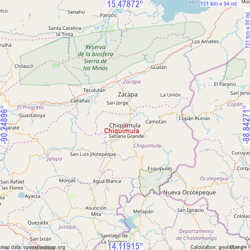
Chiquimula GPS coordinates[2]
14° 48' 0" North, 89° 32' 44.988" West
| Map corner | latitude | longitude |
|---|---|---|
| Upper-left | 15.47872°, | -90.24896° |
| Center: | 14.8°, | -89.54583° |
| Lower-right: | 14.11915°, | -88.84271° |
| Map W x H: | 151.2×151.2 km | = 94×94mi |
| max Lat: | 17.06606° ⇑49.9% North |
| Chiquimula: | 14.8° |
| min Lat: | ⇓50.1% South 13.9274° |
| min Long | Chiquimula | max Long |
| -92.19298° | -89.54583° | -88.59444° |
| W 94.1%⇐ | ⇒5.9% E |
Elevation
Elevation of Chiquimula is 425 m = 1394 ft, and this is 842 m = 2762 ft below average elevation for this country.
| Max E: |
3254 m = 10676 ft | 76.7% |
| Avg. | 1267 m = 4157 ft | |
| Chiquimula | 425 m = 1394 ft | |
Min E: |
1 m = 3 ft | 23.3% |
See also: Chiquimula elevation on elevation.city.
Geographical zone
Chiquimula is located in North Torrid zone (between Equator and Tropic of Cancer). Distance of this Northern Tropic circle is 960.3 km =596.7 mi to North.| Distance of | km | miles | from Chiquimula |
|---|---|---|---|
| North Pole | 8361.5 | 5195.6 | to North |
| Arctic Circle | 5755.6 | 3576.4 | to North |
| Tropic Cancer | 960.3 | 596.7 | to North |
| Equator | 1645.6 | 1022.5 | to South |


Nearby cities:
15 places around Chiquimula: (largest is in red/bold)
• Camotán
18.8 km =11.7 mi,  83°
83°
• Estanzuela
22.4 km =13.9 mi,  354°
354°
• Huité
23.6 km =14.7 mi,  308°
308°
• Ipala
21.8 km =13.5 mi,  200°
200°
• Jocotán
16.9 km =10.5 mi, 82°
• Olopa
24.2 km =15 mi,  119°
119°
• Quezaltepeque
21.4 km =13.3 mi,  148°
148°
• San Diego
25.6 km =15.9 mi,  265°
265°
• San Jacinto
15.6 km =9.7 mi,  161°
161°
• San Jorge
15.4 km =9.6 mi,  344°
344°
• San José La Arada
10.1 km =6.3 mi, 203°
• San Juan Ermita
13 km =8.1 mi,  107°
107°
• San Luis Jilotepeque
26.2 km =16.3 mi,  230°
230°
• Teculután
27.4 km =17 mi,  317°
317°
• Zacapa
19.2 km =11.9 mi,  4°
4°
Sources, notices
• [Note1] Compared only with cities in Guatemala existing in our database
• [Src1] Map data: © OpenStreetMap contributors (CC-BY-SA)
• [Src2] Other city data from geonames.org with taken over terms of usage.
• [Src3] Geographical zone / Annual Mean Temperature by Robert A. Rohde @ Wikipedia
