Santo Tomás La Unión geodata
Santo Tomás La Unión (Suchitepeque) is a seat of a second-order administrative division; located in Guatemala in America/Guatemala (GMT-6) time zone. With population of 7,081 people, there are 172 cities with bigger population in this country. Compared to other cities in Guatemala, 67.6% of cities are located further ↑North; 66.7% of cities are located further →East and 63.7% of cities have higher elevation than Santo Tomás La Unión. Note1


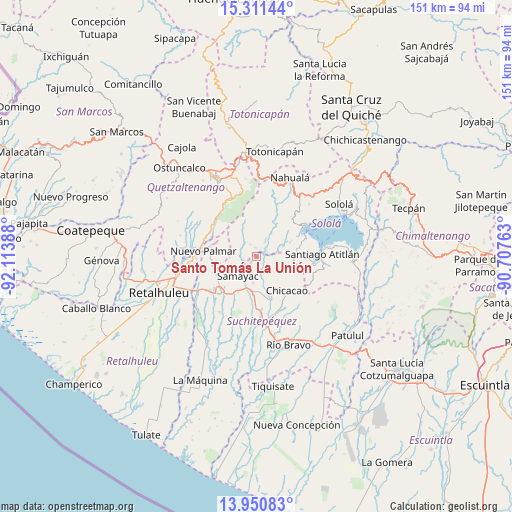
Santo Tomás La Unión GPS coordinates[2]
14° 37' 55.884" North, 91° 24' 38.7" West
| Map corner | latitude | longitude |
|---|---|---|
| Upper-left | 15.31144°, | -92.11388° |
| Center: | 14.63219°, | -91.41075° |
| Lower-right: | 13.95083°, | -90.70763° |
| Map W x H: | 151.3×151.3 km | = 94×94mi |
| max Lat: | 17.06606° ⇑67.6% North |
| Santo Tomás La Unión: | 14.63219° |
| min Lat: | ⇓32.4% South 13.9274° |
| min Long | Santo Tomás La | max Long |
| -92.19298° | -91.41075° | -88.59444° |
| W 33.3%⇐ | ⇒66.7% E |
Elevation
Elevation of Santo Tomás La Unión is 870 m = 2854 ft, and this is 397 m = 1302 ft below average elevation for this country.
| Max E: |
3254 m = 10676 ft | 63.7% |
| Avg. | 1267 m = 4157 ft | |
| Santo Tomás La Unión | 870 m = 2854 ft | |
Min E: |
1 m = 3 ft | 36.3% |
See also: Guatemala elevation on elevation.city.
Geographical zone
Santo Tomás La Unión is located in North Torrid zone (between Equator and Tropic of Cancer). Distance of this Northern Tropic circle is 979 km =608.3 mi to North.| Distance of | km | miles | from Santo Tomás La Unión |
|---|---|---|---|
| North Pole | 8380.1 | 5207.2 | to North |
| Arctic Circle | 5774.2 | 3587.9 | to North |
| Tropic Cancer | 979 | 608.3 | to North |
| Equator | 1626.9 | 1010.9 | to South |


Nearby cities:
15 places around Santo Tomás La Unión: (largest is in red/bold)
• Chicacao
13.5 km =8.4 mi,  137°
137°
• Mazatenango
14.8 km =9.2 mi,  222°
222°
• Pueblo Nuevo
13.9 km =8.6 mi,  276°
276°
• Samayac
7.9 km =4.9 mi, 223°
• San Antonio Suchitepéquez
10.3 km =6.4 mi,  182°
182°
• San Bernardino
11.2 km =7 mi,  207°
207°
• San Francisco Zapotitlán
12.8 km =8 mi,  248°
248°
• San Gabriel
17 km =10.6 mi, 217°
• San Juan La Laguna
15 km =9.3 mi,  62°
62°
• San Miguel Panán
12.4 km =7.7 mi,  157°
157°
• San Pablo Jocopilas
6.5 km =4 mi, 222°
• San Pedro La Laguna
16.4 km =10.2 mi,  65°
65°
• Santa Clara La Laguna
14.8 km =9.2 mi,  51°
51°
• Santa María Visitación
14.5 km =9 mi, 49°
• Zunilito
10.9 km =6.8 mi,  258°
258°
Sources, notices
• [Note1] Compared only with cities in Guatemala existing in our database
• [Src1] Map data: © OpenStreetMap contributors (CC-BY-SA)
• [Src2] Other city data from geonames.org with taken over terms of usage.
• [Src3] Geographical zone / Annual Mean Temperature by Robert A. Rohde @ Wikipedia
