Chicacao geodata
Chicacao (Suchitepeque) is a seat of a second-order administrative division; located in Guatemala in America/Guatemala (GMT-6) time zone. With population of 20,426 people, there are 54 cities with bigger population in this country. Compared to other cities in Guatemala, 77.6% of cities are located further ↑North; 64.6% of cities are located further →East and 73.7% of cities have higher elevation than Chicacao. Note1


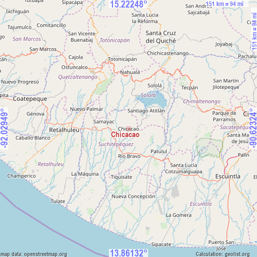
Chicacao GPS coordinates[2]
14° 32' 34.62" North, 91° 19' 34.896" West
| Map corner | latitude | longitude |
|---|---|---|
| Upper-left | 15.22248°, | -92.02949° |
| Center: | 14.54295°, | -91.32636° |
| Lower-right: | 13.86132°, | -90.62324° |
| Map W x H: | 151.3×151.4 km | = 94×94.1mi |
| max Lat: | 17.06606° ⇑77.6% North |
| Chicacao: | 14.54295° |
| min Lat: | ⇓22.4% South 13.9274° |
| min Long | Chicacao | max Long |
| -92.19298° | -91.32636° | -88.59444° |
| W 35.4%⇐ | ⇒64.6% E |
Elevation
Elevation of Chicacao is 505 m = 1657 ft, and this is 762 m = 2500 ft below average elevation for this country.
| Max E: |
3254 m = 10676 ft | 73.7% |
| Avg. | 1267 m = 4157 ft | |
| Chicacao | 505 m = 1657 ft | |
Min E: |
1 m = 3 ft | 26.3% |
See also: Guatemala elevation on elevation.city.
Geographical zone
Chicacao is located in North Torrid zone (between Equator and Tropic of Cancer). Distance of this Northern Tropic circle is 988.9 km =614.5 mi to North.| Distance of | km | miles | from Chicacao |
|---|---|---|---|
| North Pole | 8390 | 5213.3 | to North |
| Arctic Circle | 5784.1 | 3594.1 | to North |
| Tropic Cancer | 988.9 | 614.5 | to North |
| Equator | 1617 | 1004.8 | to South |


Nearby cities:
15 places around Chicacao: (largest is in red/bold)
• Mazatenango
19.1 km =11.9 mi,  267°
267°
• Río Bravo
15.9 km =9.9 mi,  176°
176°
• Samayac
15.1 km =9.4 mi,  286°
286°
• San Antonio Suchitepéquez
9.5 km =5.9 mi, 267°
• San Bernardino
14.2 km =8.8 mi, 269°
• San José El Ídolo
14.6 km =9.1 mi,  225°
225°
• San Juan La Laguna
17.4 km =10.8 mi,  14°
14°
• San Miguel Panán
4.7 km =2.9 mi,  250°
250°
• San Pablo Jocopilas
14.4 km =8.9 mi, 290°
• San Pedro La Laguna
17.7 km =11 mi,  19°
19°
• Santa Bárbara
16 km =9.9 mi,  138°
138°
• Santa Clara La Laguna
19.3 km =12 mi, 7°
• Santiago Atitlán
14.9 km =9.3 mi,  44°
44°
• Santo Domingo Suchitepéquez
18.3 km =11.4 mi, 247°
• Santo Tomás La Unión
13.5 km =8.4 mi,  317°
317°
Sources, notices
• [Note1] Compared only with cities in Guatemala existing in our database
• [Src1] Map data: © OpenStreetMap contributors (CC-BY-SA)
• [Src2] Other city data from geonames.org with taken over terms of usage.
• [Src3] Geographical zone / Annual Mean Temperature by Robert A. Rohde @ Wikipedia
