San Felipe geodata
San Felipe (Retalhuleu) is a seat of a second-order administrative division; located in Guatemala in America/Guatemala (GMT-6) time zone. With population of 8,921 people, there are 146 cities with bigger population in this country. Compared to other cities in Guatemala, 68.4% of cities are located further ↑North; 78.5% of cities are located further →East and 70.5% of cities have higher elevation than San Felipe. Note1


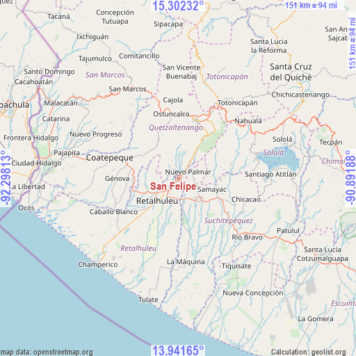
San Felipe GPS coordinates[2]
14° 37' 22.944" North, 91° 35' 42" West
| Map corner | latitude | longitude |
|---|---|---|
| Upper-left | 15.30232°, | -92.29813° |
| Center: | 14.62304°, | -91.595° |
| Lower-right: | 13.94165°, | -90.89188° |
| Map W x H: | 151.3×151.3 km | = 94×94mi |
| max Lat: | 17.06606° ⇑68.4% North |
| San Felipe: | 14.62304° |
| min Lat: | ⇓31.6% South 13.9274° |
| min Long | San Felipe | max Long |
| -92.19298° | -91.595° | -88.59444° |
| W 21.5%⇐ | ⇒78.5% E |
Elevation
Elevation of San Felipe is 604 m = 1982 ft, and this is 663 m = 2175 ft below average elevation for this country.
| Max E: |
3254 m = 10676 ft | 70.5% |
| Avg. | 1267 m = 4157 ft | |
| San Felipe | 604 m = 1982 ft | |
Min E: |
1 m = 3 ft | 29.5% |
See also: Guatemala elevation on elevation.city.
Geographical zone
San Felipe is located in North Torrid zone (between Equator and Tropic of Cancer). Distance of this Northern Tropic circle is 980 km =608.9 mi to North.| Distance of | km | miles | from San Felipe |
|---|---|---|---|
| North Pole | 8381.1 | 5207.8 | to North |
| Arctic Circle | 5775.2 | 3588.5 | to North |
| Tropic Cancer | 980 | 608.9 | to North |
| Equator | 1625.9 | 1010.3 | to South |


Nearby cities:
15 places around San Felipe: (largest is in red/bold)
• Cuyotenango
9.6 km =6 mi,  164°
164°
• El Asintal
14.6 km =9.1 mi,  258°
258°
• El Palmar
3.6 km =2.2 mi,  30°
30°
• Mazatenango
14 km =8.7 mi,  135°
135°
• Nuevo San Carlos
11.2 km =7 mi,  252°
252°
• Pueblo Nuevo
6.5 km =4 mi,  65°
65°
• Retalhuleu
13.1 km =8.1 mi,  222°
222°
• Samayac
15.1 km =9.4 mi,  108°
108°
• San Andrés Villa Seca
5.1 km =3.2 mi,  168°
168°
• San Francisco Zapotitlán
8.8 km =5.5 mi,  115°
115°
• San Gabriel
15.6 km =9.7 mi, 142°
• San Martín Zapotitlán
2.1 km =1.3 mi, 215°
• San Sebastián
8.9 km =5.5 mi, 220°
• Santa Cruz Muluá
5.6 km =3.5 mi,  214°
214°
• Zunilito
9.2 km =5.7 mi,  97°
97°
Sources, notices
• [Note1] Compared only with cities in Guatemala existing in our database
• [Src1] Map data: © OpenStreetMap contributors (CC-BY-SA)
• [Src2] Other city data from geonames.org with taken over terms of usage.
• [Src3] Geographical zone / Annual Mean Temperature by Robert A. Rohde @ Wikipedia
