La Blanca geodata
La Blanca (San Marcos) is a seat of a second-order administrative division; located in Guatemala in America/Guatemala (GMT-6) time zone. In our database, there are 325 cities with bigger population. Compared to other cities in Guatemala, 73.5% of cities are located further ↑North; 99.7% of cities are located further →East and 98.5% of cities have higher elevation than La Blanca. Note1


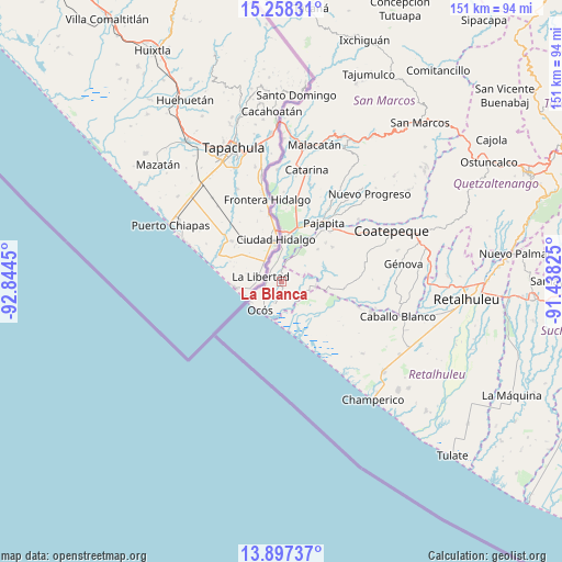
La Blanca GPS coordinates[2]
14° 34' 44.004" North, 92° 8' 28.932" West
| Map corner | latitude | longitude |
|---|---|---|
| Upper-left | 15.25831°, | -92.8445° |
| Center: | 14.57889°, | -92.14137° |
| Lower-right: | 13.89737°, | -91.43825° |
| Map W x H: | 151.3×151.3 km | = 94×94mi |
| max Lat: | 17.06606° ⇑73.5% North |
| La Blanca: | 14.57889° |
| min Lat: | ⇓26.5% South 13.9274° |
| min Long | La Blanca | max Long |
| -92.19298° | -92.14137° | -88.59444° |
| W 0.3%⇐ | ⇒99.7% E |
Elevation
Elevation of La Blanca is 16 m = 52 ft, and this is 1251 m = 4104 ft below average elevation for this country.
| Max E: |
3254 m = 10676 ft | 98.5% |
| Avg. | 1267 m = 4157 ft | |
| La Blanca | 16 m = 52 ft | |
Min E: |
1 m = 3 ft | 1.5% |
See also: Guatemala elevation on elevation.city.
Geographical zone
La Blanca is located in North Torrid zone (between Equator and Tropic of Cancer). Distance of this Northern Tropic circle is 984.9 km =612 mi to North.| Distance of | km | miles | from La Blanca |
|---|---|---|---|
| North Pole | 8386 | 5210.8 | to North |
| Arctic Circle | 5780.2 | 3591.6 | to North |
| Tropic Cancer | 984.9 | 612 | to North |
| Equator | 1621 | 1007.2 | to South |


Nearby cities:
15 places around La Blanca: (largest is in red/bold)
• Catarina
31.3 km =19.4 mi,  12°
12°
• Champerico
40.2 km =25 mi,  142°
142°
• Ciudad Tecún Umán
11 km =6.8 mi,  0°
0°
• Coatepeque
32.9 km =20.4 mi,  64°
64°
• El Quetzal
40.7 km =25.3 mi, 58°
• El Rodeo
41.3 km =25.7 mi,  25°
25°
• El Tumbador
38.7 km =24 mi,  35°
35°
• Flores Costa Cuca
30.5 km =19 mi,  78°
78°
• Génova
33.4 km =20.8 mi, 82°
• La Reforma
42.3 km =26.3 mi,  54°
54°
• Malacatán
38 km =23.6 mi, 13°
• Nuevo Progreso
33.6 km =20.9 mi, 45°
• Ocós
9.5 km =5.9 mi,  215°
215°
• Pajapita
19.5 km =12.1 mi, 35°
• San Pablo
42 km =26.1 mi,  20°
20°
Sources, notices
• [Note1] Compared only with cities in Guatemala existing in our database
• [Src1] Map data: © OpenStreetMap contributors (CC-BY-SA)
• [Src2] Other city data from geonames.org with taken over terms of usage.
• [Src3] Geographical zone / Annual Mean Temperature by Robert A. Rohde @ Wikipedia
