Génova geodata
Génova (Quetzaltenango) is a seat of a second-order administrative division; located in Guatemala in America/Guatemala (GMT-6) time zone. With population of 3,744 people, there are 226 cities with bigger population in this country. Compared to other cities in Guatemala, 69.3% of cities are located further ↑North; 92.6% of cities are located further →East and 81.1% of cities have higher elevation than Génova. Note1


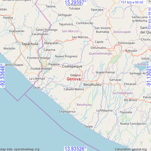
Génova GPS coordinates[2]
14° 37' 0.012" North, 91° 49' 59.988" West
| Map corner | latitude | longitude |
|---|---|---|
| Upper-left | 15.29597°, | -92.53646° |
| Center: | 14.61667°, | -91.83333° |
| Lower-right: | 13.93526°, | -91.13021° |
| Map W x H: | 151.3×151.3 km | = 94×94mi |
| max Lat: | 17.06606° ⇑69.3% North |
| Génova: | 14.61667° |
| min Lat: | ⇓30.7% South 13.9274° |
| min Long | Génova | max Long |
| -92.19298° | -91.83333° | -88.59444° |
| W 7.4%⇐ | ⇒92.6% E |
Elevation
Elevation of Génova is 352 m = 1155 ft, and this is 915 m = 3002 ft below average elevation for this country.
| Max E: |
3254 m = 10676 ft | 81.1% |
| Avg. | 1267 m = 4157 ft | |
| Génova | 352 m = 1155 ft | |
Min E: |
1 m = 3 ft | 18.9% |
See also: Guatemala elevation on elevation.city.
Geographical zone
Génova is located in North Torrid zone (between Equator and Tropic of Cancer). Distance of this Northern Tropic circle is 980.7 km =609.4 mi to North.| Distance of | km | miles | from Génova |
|---|---|---|---|
| North Pole | 8381.8 | 5208.2 | to North |
| Arctic Circle | 5776 | 3589 | to North |
| Tropic Cancer | 980.7 | 609.4 | to North |
| Equator | 1625.2 | 1009.9 | to South |


Nearby cities:
15 places around Génova: (largest is in red/bold)
• Coatepeque
10.3 km =6.4 mi,  341°
341°
• Colomba
14.9 km =9.3 mi,  47°
47°
• El Asintal
11.6 km =7.2 mi,  101°
101°
• El Quetzal
17 km =10.6 mi,  5°
5°
• Flores Costa Cuca
3.7 km =2.3 mi,  298°
298°
• La Reforma
20.5 km =12.7 mi,  3°
3°
• Nuevo Progreso
21.6 km =13.4 mi,  334°
334°
• Nuevo San Carlos
15.2 km =9.4 mi, 99°
• Pajapita
24.6 km =15.3 mi, 298°
• Retalhuleu
19 km =11.8 mi,  118°
118°
• San Andrés Villa Seca
27 km =16.8 mi, 99°
• San Felipe
25.7 km =16 mi,  88°
88°
• San Martín Zapotitlán
24.5 km =15.2 mi, 92°
• San Sebastián
20.8 km =12.9 mi,  107°
107°
• Santa Cruz Muluá
22.8 km =14.2 mi, 99°
Sources, notices
• [Note1] Compared only with cities in Guatemala existing in our database
• [Src1] Map data: © OpenStreetMap contributors (CC-BY-SA)
• [Src2] Other city data from geonames.org with taken over terms of usage.
• [Src3] Geographical zone / Annual Mean Temperature by Robert A. Rohde @ Wikipedia
