Champerico geodata
Champerico (Retalhuleu) is a seat of a second-order administrative division; located in Guatemala in America/Guatemala (GMT-6) time zone. With population of 7,761 people, there are 162 cities with bigger population in this country. Compared to other cities in Guatemala, 91.4% of cities are located further ↑North; 94.4% of cities are located further →East and 100% of cities have higher elevation than Champerico. Note1


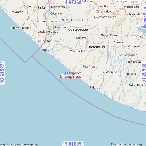
Champerico GPS coordinates[2]
14° 17' 36.132" North, 91° 54' 43.704" West
| Map corner | latitude | longitude |
|---|---|---|
| Upper-left | 14.97368°, | -92.61527° |
| Center: | 14.29337°, | -91.91214° |
| Lower-right: | 13.61099°, | -91.20902° |
| Map W x H: | 151.5×151.5 km | = 94.1×94.1mi |
| max Lat: | 17.06606° ⇑91.4% North |
| Champerico: | 14.29337° |
| min Lat: | ⇓8.6% South 13.9274° |
| min Long | Champerico | max Long |
| -92.19298° | -91.91214° | -88.59444° |
| W 5.6%⇐ | ⇒94.4% E |
Elevation
Elevation of Champerico is 1 m = 3 ft, and this is 1266 m = 4154 ft below average elevation for this country.
| Max E: |
3254 m = 10676 ft | 100% |
| Avg. | 1267 m = 4157 ft | |
| Champerico | 1 m = 3 ft | |
Min E: |
1 m = 3 ft | 0% |
See also: Guatemala elevation on elevation.city.
Geographical zone
Champerico is located in North Torrid zone (between Equator and Tropic of Cancer). Distance of this Northern Tropic circle is 1016.6 km =631.7 mi to North.| Distance of | km | miles | from Champerico |
|---|---|---|---|
| North Pole | 8417.8 | 5230.6 | to North |
| Arctic Circle | 5811.9 | 3611.3 | to North |
| Tropic Cancer | 1016.6 | 631.7 | to North |
| Equator | 1589.3 | 987.5 | to South |


Nearby cities:
15 places around Champerico: (largest is in red/bold)
• Coatepeque
46 km =28.6 mi,  6°
6°
• Cuyotenango
45.8 km =28.5 mi,  53°
53°
• El Asintal
39.1 km =24.3 mi,  30°
30°
• Flores Costa Cuca
38.1 km =23.7 mi, 7°
• Génova
36.9 km =22.9 mi, 13°
• La Blanca
40.2 km =25 mi,  322°
322°
• La Máquina
37.2 km =23.1 mi,  88°
88°
• Nuevo San Carlos
40.8 km =25.4 mi,  35°
35°
• Ocós
38.7 km =24 mi,  308°
308°
• Retalhuleu
37 km =23 mi, 43°
• San Andrés Villa Seca
47.3 km =29.4 mi, 48°
• San Lorenzo
48.1 km =29.9 mi,  63°
63°
• San Martín Zapotitlán
48.1 km =29.9 mi, 43°
• San Sebastián
41.2 km =25.6 mi, 43°
• Santa Cruz Muluá
44.6 km =27.7 mi, 44°
Sources, notices
• [Note1] Compared only with cities in Guatemala existing in our database
• [Src1] Map data: © OpenStreetMap contributors (CC-BY-SA)
• [Src2] Other city data from geonames.org with taken over terms of usage.
• [Src3] Geographical zone / Annual Mean Temperature by Robert A. Rohde @ Wikipedia
