San Lucas Sacatepéquez geodata
San Lucas Sacatepéquez (Sacatepéquez) is a seat of a second-order administrative division; located in Guatemala in America/Guatemala (GMT-6) time zone. With population of 17,959 people, there are 67 cities with bigger population in this country. Compared to other cities in Guatemala, 69.9% of cities are located further ↑North; 61.7% of cities are located further ←West and 79.9% of cities have lower elevation than San Lucas Sacatepéquez. Note1


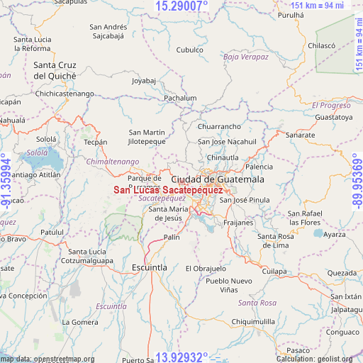
San Lucas Sacatepéquez GPS coordinates[2]
14° 36' 38.7" North, 90° 39' 24.516" West
| Map corner | latitude | longitude |
|---|---|---|
| Upper-left | 15.29007°, | -91.35994° |
| Center: | 14.61075°, | -90.65681° |
| Lower-right: | 13.92932°, | -89.95369° |
| Map W x H: | 151.3×151.3 km | = 94×94mi |
| max Lat: | 17.06606° ⇑69.9% North |
| San Lucas Sacatepéquez: | 14.61075° |
| min Lat: | ⇓30.1% South 13.9274° |
| min Long | San Lucas Sacat | max Long |
| -92.19298° | -90.65681° | -88.59444° |
| W 61.7%⇐ | ⇒38.3% E |
Elevation
Elevation of San Lucas Sacatepéquez is 2087 m = 6847 ft, and this is 820 m = 2690 ft above average elevation for this country.
| Max E: |
3254 m = 10676 ft | 20.1% |
| San Lucas Sacatepéquez | 2087 m 6847 ft | |
| Avg. | 1267 m = 4157 ft | |
Min E: |
1 m = 3 ft | 79.9% |
See also: Guatemala elevation on elevation.city.
Geographical zone
San Lucas Sacatepéquez is located in North Torrid zone (between Equator and Tropic of Cancer). Distance of this Northern Tropic circle is 981.4 km =609.8 mi to North.| Distance of | km | miles | from San Lucas Sacatepéquez |
|---|---|---|---|
| North Pole | 8382.5 | 5208.6 | to North |
| Arctic Circle | 5776.6 | 3589.4 | to North |
| Tropic Cancer | 981.4 | 609.8 | to North |
| Equator | 1624.6 | 1009.5 | to South |


Nearby cities:
15 places around San Lucas Sacatepéquez: (largest is in red/bold)
• Amatitlán
15 km =9.3 mi,  170°
170°
• Antigua Guatemala
10 km =6.2 mi,  236°
236°
• Jocotenango
9.5 km =5.9 mi,  247°
247°
• Magdalena Milpas Altas
7.2 km =4.5 mi,  195°
195°
• Mixco
5.8 km =3.6 mi,  67°
67°
• Pastores
10.7 km =6.6 mi,  260°
260°
• San Bartolomé Milpas Altas
2.3 km =1.4 mi, 259°
• San Juan Sacatepéquez
12.1 km =7.5 mi,  6°
6°
• San Pedro Sacatepéquez
8.5 km =5.3 mi, 10°
• Santa Lucía Milpas Altas
4.3 km =2.7 mi,  208°
208°
• Santa María de Jesús
14.2 km =8.8 mi, 204°
• Santiago Sacatepéquez
3.4 km =2.1 mi,  321°
321°
• Santo Domingo Xenacoj
9.1 km =5.7 mi,  329°
329°
• Sumpango
9.2 km =5.7 mi,  295°
295°
• Villa Nueva
12.2 km =7.6 mi,  141°
141°
Sources, notices
• [Note1] Compared only with cities in Guatemala existing in our database
• [Src1] Map data: © OpenStreetMap contributors (CC-BY-SA)
• [Src2] Other city data from geonames.org with taken over terms of usage.
• [Src3] Geographical zone / Annual Mean Temperature by Robert A. Rohde @ Wikipedia
