Oropolí geodata
Oropolí (El Paraíso) is a populated place; located in Honduras in America/Tegucigalpa (GMT-6) time zone. With population of 1,412 people, there are 263 cities with bigger population in this country. Compared to other cities in Honduras, 91% of cities are located further ↑North; 78.2% of cities are located further ←West and 55.8% of cities have higher elevation than Oropolí. Note1


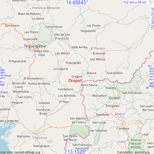
Oropolí GPS coordinates[2]
13° 49' 0.012" North, 86° 49' 0.012" West
| Map corner | latitude | longitude |
|---|---|---|
| Upper-left | 14.49843°, | -87.5198° |
| Center: | 13.81667°, | -86.81667° |
| Lower-right: | 13.1329°, | -86.11355° |
| Map W x H: | 151.8×151.8 km | = 94.3×94.3mi |
| max Lat: | 16.45° ⇑91% North |
| Oropolí: | 13.81667° |
| min Lat: | ⇓9% South 13.11667° |
| min Long | Oropolí | max Long |
| -89.23333° | -86.81667° | -83.23333° |
| W 78.2%⇐ | ⇒21.8% E |
Elevation
Elevation of Oropolí is 472 m = 1549 ft, and this is 89.2 m = 293 ft below average elevation for this country.
| Max E: |
1811 m = 5942 ft | 55.8% |
| Avg. | 561.2 m = 1841 ft | |
| Oropolí | 472 m = 1549 ft | |
Min E: |
1 m = 3 ft | 44.2% |
See also: Honduras elevation on elevation.city.
Geographical zone
Oropolí is located in North Torrid zone (between Equator and Tropic of Cancer). Distance of this Northern Tropic circle is 1069.6 km =664.6 mi to North.| Distance of | km | miles | from Oropolí |
|---|---|---|---|
| North Pole | 8470.8 | 5263.5 | to North |
| Arctic Circle | 5864.9 | 3644.3 | to North |
| Tropic Cancer | 1069.6 | 664.6 | to North |
| Equator | 1536.3 | 954.6 | to South |


Nearby cities:
15 places around Oropolí: (largest is in red/bold)
• Araulí
32.4 km =20.1 mi,  62°
62°
• Cuyalí
29.7 km =18.5 mi,  75°
75°
• Duyure
20.4 km =12.7 mi,  180°
180°
• El Paraíso
29.3 km =18.2 mi, 79°
• El Pescadero
31.6 km =19.6 mi,  65°
65°
• Güinope
14.6 km =9.1 mi,  300°
300°
• Jacaleapa
27.5 km =17.1 mi,  36°
36°
• Mandasta
14.2 km =8.8 mi,  229°
229°
• Morocelí
33.8 km =21 mi,  350°
350°
• Morolica
29.2 km =18.1 mi,  197°
197°
• San Lucas
17.1 km =10.6 mi,  237°
237°
• San Matías
27.1 km =16.8 mi,  46°
46°
• Santa Cruz
20.6 km =12.8 mi, 74°
• Texíguat
29 km =18 mi, 230°
• Yuscarán
14.7 km =9.1 mi,  344°
344°
Sources, notices
• [Note1] Compared only with cities in Honduras existing in our database
• [Src1] Map data: © OpenStreetMap contributors (CC-BY-SA)
• [Src2] Other city data from geonames.org with taken over terms of usage.
• [Src3] Geographical zone / Annual Mean Temperature by Robert A. Rohde @ Wikipedia
