Francia geodata
Francia (Colón) is a populated place; located in Honduras in America/Tegucigalpa (GMT-6) time zone. With population of 1,331 people, there are 280 cities with bigger population in this country. Compared to other cities in Honduras, 97.4% of cities are located further ↓South; 97.2% of cities are located further ←West and 98.8% of cities have higher elevation than Francia. Note1


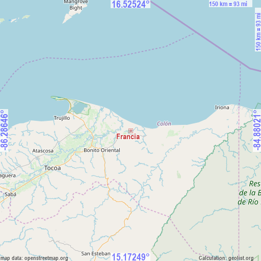
Francia GPS coordinates[2]
15° 51' 0" North, 85° 34' 59.988" West
| Map corner | latitude | longitude |
|---|---|---|
| Upper-left | 16.52524°, | -86.28646° |
| Center: | 15.85°, | -85.58333° |
| Lower-right: | 15.17249°, | -84.88021° |
| Map W x H: | 150.4×150.4 km | = 93.5×93.5mi |
| max Lat: | 16.45° ⇑2.6% North |
| Francia: | 15.85° |
| min Lat: | ⇓97.4% South 13.11667° |
| min Long | Francia | max Long |
| -89.23333° | -85.58333° | -83.23333° |
| W 97.2%⇐ | ⇒2.8% E |
Elevation
Elevation of Francia is 4 m = 13 ft, and this is 557.2 m = 1828 ft below average elevation for this country.
| Max E: |
1811 m = 5942 ft | 98.8% |
| Avg. | 561.2 m = 1841 ft | |
| Francia | 4 m = 13 ft | |
Min E: |
1 m = 3 ft | 1.2% |
See also: Honduras elevation on elevation.city.
Geographical zone
Francia is located in North Torrid zone (between Equator and Tropic of Cancer). Distance of this Northern Tropic circle is 843.6 km =524.2 mi to North.| Distance of | km | miles | from Francia |
|---|---|---|---|
| North Pole | 8244.7 | 5123 | to North |
| Arctic Circle | 5638.8 | 3503.8 | to North |
| Tropic Cancer | 843.6 | 524.2 | to North |
| Equator | 1762.4 | 1095.1 | to South |


Nearby cities:
15 places around Francia: (largest is in red/bold)
• Bonito Oriental
19.9 km =12.4 mi,  235°
235°
• Corocito
24.1 km =15 mi, 242°
• Cusuna
37.4 km =23.2 mi,  90°
90°
• Jericó
42.5 km =26.4 mi,  285°
285°
• La Brea
41.4 km =25.7 mi,  262°
262°
• La Curva
20.4 km =12.7 mi,  254°
254°
• La Esperanza
31.1 km =19.3 mi,  219°
219°
• Puerto Castilla
45 km =28 mi, 294°
• Punta Piedra
32.6 km =20.3 mi,  80°
80°
• Quebrada de Arena
36.8 km =22.9 mi, 255°
• Salamá
42.5 km =26.4 mi, 254°
• Santa Rosa de Aguán
18.1 km =11.2 mi,  307°
307°
• Taujica
39.4 km =24.5 mi, 244°
• Tocoa
48.3 km =30 mi, 247°
• Trujillo
40.3 km =25 mi,  280°
280°
Sources, notices
• [Note1] Compared only with cities in Honduras existing in our database
• [Src1] Map data: © OpenStreetMap contributors (CC-BY-SA)
• [Src2] Other city data from geonames.org with taken over terms of usage.
• [Src3] Geographical zone / Annual Mean Temperature by Robert A. Rohde @ Wikipedia
