San Nicolás geodata
San Nicolás (Comayagua) is a populated place; located in Honduras in America/Tegucigalpa (GMT-6) time zone. With population of 976 people, there are 432 cities with bigger population in this country. Compared to other cities in Honduras, 60% of cities are located further ↑North; 59.4% of cities are located further ←West and 51.8% of cities have lower elevation than San Nicolás. Note1


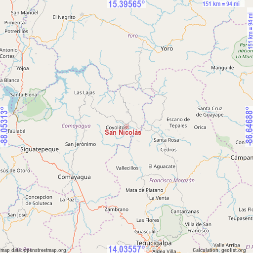
San Nicolás GPS coordinates[2]
14° 43' 0.012" North, 87° 21' 0" West
| Map corner | latitude | longitude |
|---|---|---|
| Upper-left | 15.39565°, | -88.05313° |
| Center: | 14.71667°, | -87.35° |
| Lower-right: | 14.03557°, | -86.64688° |
| Map W x H: | 151.2×151.2 km | = 94×94mi |
| max Lat: | 16.45° ⇑60% North |
| San Nicolás: | 14.71667° |
| min Lat: | ⇓40% South 13.11667° |
| min Long | San Nicolás | max Long |
| -89.23333° | -87.35° | -83.23333° |
| W 59.4%⇐ | ⇒40.6% E |
Elevation
Elevation of San Nicolás is 586 m = 1923 ft, and this is 24.8 m = 81 ft above average elevation for this country.
| Max E: |
1811 m = 5942 ft | 48.2% |
| San Nicolás | 586 m 1923 ft | |
| Avg. | 561.2 m = 1841 ft | |
Min E: |
1 m = 3 ft | 51.8% |
See also: Honduras elevation on elevation.city.
Geographical zone
San Nicolás is located in North Torrid zone (between Equator and Tropic of Cancer). Distance of this Northern Tropic circle is 969.6 km =602.5 mi to North.| Distance of | km | miles | from San Nicolás |
|---|---|---|---|
| North Pole | 8370.7 | 5201.3 | to North |
| Arctic Circle | 5764.8 | 3582.1 | to North |
| Tropic Cancer | 969.6 | 602.5 | to North |
| Equator | 1636.3 | 1016.7 | to South |


Nearby cities:
15 places around San Nicolás: (largest is in red/bold)
• Cedros
28.3 km =17.6 mi,  117°
117°
• El Escanito
27.5 km =17.1 mi,  101°
101°
• El Guantillo
14 km =8.7 mi,  157°
157°
• El Pedernal
25.2 km =15.7 mi,  94°
94°
• El Rancho
16.6 km =10.3 mi,  257°
257°
• El Suyatal
26.5 km =16.5 mi,  147°
147°
• Esquías
2.6 km =1.6 mi,  315°
315°
• Jamalteca
25.2 km =15.7 mi,  265°
265°
• Mata de Plátano
14.8 km =9.2 mi, 151°
• Minas de Oro
9.3 km =5.8 mi,  0°
0°
• Quebradas
24.1 km =15 mi,  180°
180°
• San José del Potrero
14.8 km =9.2 mi,  28°
28°
• San Luis
8.1 km =5 mi,  297°
297°
• Sulaco
24 km =14.9 mi,  21°
21°
• Vallecillo
22.9 km =14.2 mi,  193°
193°
Sources, notices
• [Note1] Compared only with cities in Honduras existing in our database
• [Src1] Map data: © OpenStreetMap contributors (CC-BY-SA)
• [Src2] Other city data from geonames.org with taken over terms of usage.
• [Src3] Geographical zone / Annual Mean Temperature by Robert A. Rohde @ Wikipedia
