El Rancho geodata
El Rancho (Comayagua) is a populated place; located in Honduras in America/Tegucigalpa (GMT-6) time zone. With population of 1,484 people, there are 242 cities with bigger population in this country. Compared to other cities in Honduras, 62.4% of cities are located further ↑North; 54.2% of cities are located further ←West and 82.8% of cities have lower elevation than El Rancho. Note1


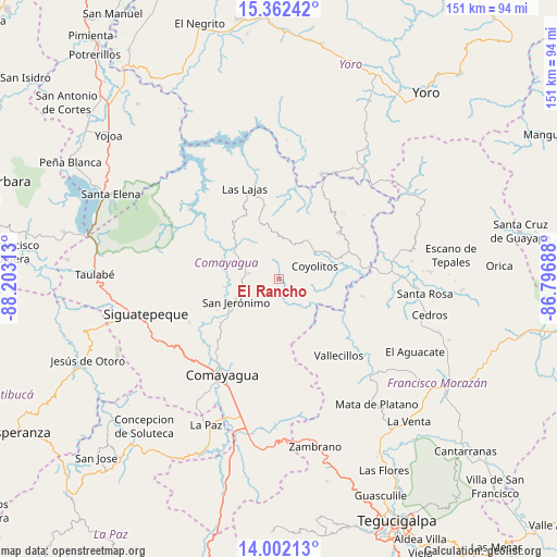
El Rancho GPS coordinates[2]
14° 40' 59.988" North, 87° 30' 0" West
| Map corner | latitude | longitude |
|---|---|---|
| Upper-left | 15.36242°, | -88.20313° |
| Center: | 14.68333°, | -87.5° |
| Lower-right: | 14.00213°, | -86.79688° |
| Map W x H: | 151.3×151.3 km | = 94×94mi |
| max Lat: | 16.45° ⇑62.4% North |
| El Rancho: | 14.68333° |
| min Lat: | ⇓37.6% South 13.11667° |
| min Long | El Rancho | max Long |
| -89.23333° | -87.5° | -83.23333° |
| W 54.2%⇐ | ⇒45.8% E |
Elevation
Elevation of El Rancho is 984 m = 3228 ft, and this is 422.8 m = 1387 ft above average elevation for this country.
| Max E: |
1811 m = 5942 ft | 17.2% |
| El Rancho | 984 m 3228 ft | |
| Avg. | 561.2 m = 1841 ft | |
Min E: |
1 m = 3 ft | 82.8% |
See also: Honduras elevation on elevation.city.
Geographical zone
El Rancho is located in North Torrid zone (between Equator and Tropic of Cancer). Distance of this Northern Tropic circle is 973.3 km =604.8 mi to North.| Distance of | km | miles | from El Rancho |
|---|---|---|---|
| North Pole | 8374.4 | 5203.6 | to North |
| Arctic Circle | 5768.5 | 3584.4 | to North |
| Tropic Cancer | 973.3 | 604.8 | to North |
| Equator | 1632.6 | 1014.5 | to South |


Nearby cities:
15 places around El Rancho: (largest is in red/bold)
• Concepción de Guasistagua
18.6 km =11.6 mi,  240°
240°
• El Guantillo
23.4 km =14.5 mi,  113°
113°
• El Sauce
24.8 km =15.4 mi,  226°
226°
• Esquías
15.4 km =9.6 mi,  68°
68°
• Jamalteca
9.2 km =5.7 mi,  281°
281°
• La Libertad
14.6 km =9.1 mi,  300°
300°
• La Trinidad
18.3 km =11.4 mi, 281°
• Mata de Plátano
25.1 km =15.6 mi, 111°
• Minas de Oro
20.7 km =12.9 mi,  51°
51°
• San Antonio de la Cuesta
12.1 km =7.5 mi, 242°
• San Jerónimo
12.1 km =7.5 mi, 242°
• San Luis
11.6 km =7.2 mi, 50°
• San Nicolás
16.6 km =10.3 mi,  77°
77°
• Valle de Ángeles
24.9 km =15.5 mi,  215°
215°
• Vallecillo
21.4 km =13.3 mi,  149°
149°
Sources, notices
• [Note1] Compared only with cities in Honduras existing in our database
• [Src1] Map data: © OpenStreetMap contributors (CC-BY-SA)
• [Src2] Other city data from geonames.org with taken over terms of usage.
• [Src3] Geographical zone / Annual Mean Temperature by Robert A. Rohde @ Wikipedia
