Esquías geodata
Esquías (Comayagua) is a populated place; located in Honduras in America/Tegucigalpa (GMT-6) time zone. With population of 1,339 people, there are 276 cities with bigger population in this country. Compared to other cities in Honduras, 59% of cities are located further ↑North; 58.8% of cities are located further ←West and 66.2% of cities have lower elevation than Esquías. Note1


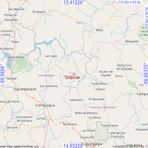
Esquías GPS coordinates[2]
14° 43' 59.988" North, 87° 22' 0.012" West
| Map corner | latitude | longitude |
|---|---|---|
| Upper-left | 15.41226°, | -88.0698° |
| Center: | 14.73333°, | -87.36667° |
| Lower-right: | 14.05228°, | -86.66355° |
| Map W x H: | 151.2×151.2 km | = 94×94mi |
| max Lat: | 16.45° ⇑59% North |
| Esquías: | 14.73333° |
| min Lat: | ⇓41% South 13.11667° |
| min Long | Esquías | max Long |
| -89.23333° | -87.36667° | -83.23333° |
| W 58.8%⇐ | ⇒41.2% E |
Elevation
Elevation of Esquías is 742 m = 2434 ft, and this is 180.8 m = 593 ft above average elevation for this country.
| Max E: |
1811 m = 5942 ft | 33.8% |
| Esquías | 742 m 2434 ft | |
| Avg. | 561.2 m = 1841 ft | |
Min E: |
1 m = 3 ft | 66.2% |
See also: Honduras elevation on elevation.city.
Geographical zone
Esquías is located in North Torrid zone (between Equator and Tropic of Cancer). Distance of this Northern Tropic circle is 967.7 km =601.3 mi to North.| Distance of | km | miles | from Esquías |
|---|---|---|---|
| North Pole | 8368.9 | 5200.2 | to North |
| Arctic Circle | 5763 | 3581 | to North |
| Tropic Cancer | 967.7 | 601.3 | to North |
| Equator | 1638.2 | 1017.9 | to South |


Nearby cities:
15 places around Esquías: (largest is in red/bold)
• El Guantillo
16.5 km =10.3 mi,  154°
154°
• El Pedernal
27.1 km =16.8 mi,  97°
97°
• El Rancho
15.4 km =9.6 mi,  248°
248°
• Jamalteca
23.6 km =14.7 mi,  260°
260°
• La Libertad
26.9 km =16.7 mi,  273°
273°
• Mata de Plátano
17.3 km =10.7 mi, 148°
• Minas de Oro
7.6 km =4.7 mi,  13°
13°
• Quebradas
26 km =16.2 mi,  176°
176°
• San Antonio de la Cuesta
27.4 km =17 mi, 246°
• San Jerónimo
27.4 km =17 mi, 246°
• San José del Potrero
14.3 km =8.9 mi,  38°
38°
• San Luis
5.7 km =3.5 mi,  289°
289°
• San Nicolás
2.6 km =1.6 mi,  135°
135°
• Sulaco
23 km =14.3 mi,  27°
27°
• Vallecillo
24.4 km =15.2 mi,  188°
188°
Sources, notices
• [Note1] Compared only with cities in Honduras existing in our database
• [Src1] Map data: © OpenStreetMap contributors (CC-BY-SA)
• [Src2] Other city data from geonames.org with taken over terms of usage.
• [Src3] Geographical zone / Annual Mean Temperature by Robert A. Rohde @ Wikipedia
