Sulaco geodata
Sulaco (Yoro) is a populated place; located in Honduras in America/Tegucigalpa (GMT-6) time zone. With population of 2,760 people, there are 124 cities with bigger population in this country. Compared to other cities in Honduras, 52% of cities are located further ↓South; 63.8% of cities are located further ←West and 58.8% of cities have higher elevation than Sulaco. Note1


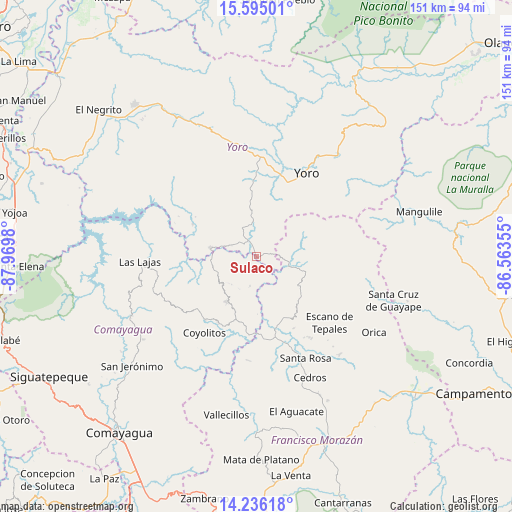
Sulaco GPS coordinates[2]
14° 55' 0.012" North, 87° 16' 0.012" West
| Map corner | latitude | longitude |
|---|---|---|
| Upper-left | 15.59501°, | -87.9698° |
| Center: | 14.91667°, | -87.26667° |
| Lower-right: | 14.23618°, | -86.56355° |
| Map W x H: | 151.1×151.1 km | = 93.9×93.9mi |
| max Lat: | 16.45° ⇑48% North |
| Sulaco: | 14.91667° |
| min Lat: | ⇓52% South 13.11667° |
| min Long | Sulaco | max Long |
| -89.23333° | -87.26667° | -83.23333° |
| W 63.8%⇐ | ⇒36.2% E |
Elevation
Elevation of Sulaco is 419 m = 1375 ft, and this is 142.2 m = 467 ft below average elevation for this country.
| Max E: |
1811 m = 5942 ft | 58.8% |
| Avg. | 561.2 m = 1841 ft | |
| Sulaco | 419 m = 1375 ft | |
Min E: |
1 m = 3 ft | 41.2% |
See also: Honduras elevation on elevation.city.
Geographical zone
Sulaco is located in North Torrid zone (between Equator and Tropic of Cancer). Distance of this Northern Tropic circle is 947.3 km =588.6 mi to North.| Distance of | km | miles | from Sulaco |
|---|---|---|---|
| North Pole | 8348.5 | 5187.5 | to North |
| Arctic Circle | 5742.6 | 3568.3 | to North |
| Tropic Cancer | 947.3 | 588.6 | to North |
| Equator | 1658.6 | 1030.6 | to South |


Nearby cities:
15 places around Sulaco: (largest is in red/bold)
• Ayapa
23.8 km =14.8 mi,  24°
24°
• El Bálsamo
27.2 km =16.9 mi,  307°
307°
• El Escaño de Tepale
28.4 km =17.6 mi,  130°
130°
• Esquías
23 km =14.3 mi,  207°
207°
• La Trinidad
21.6 km =13.4 mi, 19°
• Las Vegas
22.6 km =14 mi,  299°
299°
• Lomitas
21.1 km =13.1 mi,  14°
14°
• Marale
13.1 km =8.1 mi,  106°
106°
• Minas de Oro
15.8 km =9.8 mi, 214°
• Paujiles
22.3 km =13.9 mi,  336°
336°
• San José del Potrero
9.4 km =5.8 mi,  190°
190°
• San Luis
24.6 km =15.3 mi,  221°
221°
• San Nicolás
24 km =14.9 mi,  201°
201°
• Santa Rita
27.9 km =17.3 mi,  356°
356°
• Yorito
16.8 km =10.4 mi,  353°
353°
Sources, notices
• [Note1] Compared only with cities in Honduras existing in our database
• [Src1] Map data: © OpenStreetMap contributors (CC-BY-SA)
• [Src2] Other city data from geonames.org with taken over terms of usage.
• [Src3] Geographical zone / Annual Mean Temperature by Robert A. Rohde @ Wikipedia
