La Estancia geodata
La Estancia (Olancho) is a populated place; located in Honduras in America/Tegucigalpa (GMT-6) time zone. With population of 1,508 people, there are 238 cities with bigger population in this country. Compared to other cities in Honduras, 61.4% of cities are located further ↓South; 88.4% of cities are located further ←West and 89% of cities have lower elevation than La Estancia. Note1


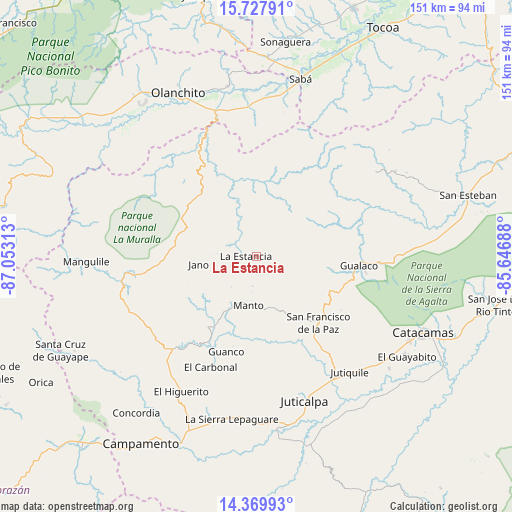
La Estancia GPS coordinates[2]
15° 3' 0" North, 86° 21' 0" West
| Map corner | latitude | longitude |
|---|---|---|
| Upper-left | 15.72791°, | -87.05313° |
| Center: | 15.05°, | -86.35° |
| Lower-right: | 14.36993°, | -85.64688° |
| Map W x H: | 151×151 km | = 93.8×93.8mi |
| max Lat: | 16.45° ⇑38.6% North |
| La Estancia: | 15.05° |
| min Lat: | ⇓61.4% South 13.11667° |
| min Long | La Estancia | max Long |
| -89.23333° | -86.35° | -83.23333° |
| W 88.4%⇐ | ⇒11.6% E |
Elevation
Elevation of La Estancia is 1132 m = 3714 ft, and this is 570.8 m = 1873 ft above average elevation for this country.
| Max E: |
1811 m = 5942 ft | 11% |
| La Estancia | 1132 m 3714 ft | |
| Avg. | 561.2 m = 1841 ft | |
Min E: |
1 m = 3 ft | 89% |
See also: Honduras elevation on elevation.city.
Geographical zone
La Estancia is located in North Torrid zone (between Equator and Tropic of Cancer). Distance of this Northern Tropic circle is 932.5 km =579.4 mi to North.| Distance of | km | miles | from La Estancia |
|---|---|---|---|
| North Pole | 8333.7 | 5178.3 | to North |
| Arctic Circle | 5727.8 | 3559.1 | to North |
| Tropic Cancer | 932.5 | 579.4 | to North |
| Equator | 1673.4 | 1039.8 | to South |


Nearby cities:
15 places around La Estancia: (largest is in red/bold)
• Chirinos
46.3 km =28.8 mi,  327°
327°
• El Guayabito
41.7 km =25.9 mi,  125°
125°
• El Juncal
45.4 km =28.2 mi,  348°
348°
• El Rosario
39.5 km =24.5 mi,  245°
245°
• Gualaco
30.1 km =18.7 mi,  95°
95°
• Guarizama
14.9 km =9.3 mi,  173°
173°
• Juticalpa
44.9 km =27.9 mi,  161°
161°
• La Concepción
40.9 km =25.4 mi, 162°
• La Guata
5.2 km =3.2 mi,  316°
316°
• Manto
15.3 km =9.5 mi,  193°
193°
• Salamá
34.8 km =21.6 mi,  226°
226°
• San Francisco de la Paz
23.2 km =14.4 mi,  135°
135°
• Silca
31.1 km =19.3 mi,  219°
219°
• Teguajinal
44.3 km =27.5 mi, 322°
• Tepusteca
40.9 km =25.4 mi,  5°
5°
Sources, notices
• [Note1] Compared only with cities in Honduras existing in our database
• [Src1] Map data: © OpenStreetMap contributors (CC-BY-SA)
• [Src2] Other city data from geonames.org with taken over terms of usage.
• [Src3] Geographical zone / Annual Mean Temperature by Robert A. Rohde @ Wikipedia
