Salamá geodata
Salamá (Olancho) is a populated place; located in Honduras in America/Tegucigalpa (GMT-6) time zone. With population of 2,820 people, there are 120 cities with bigger population in this country. Compared to other cities in Honduras, 53% of cities are located further ↑North; 82.6% of cities are located further ←West and 59.8% of cities have lower elevation than Salamá. Note1


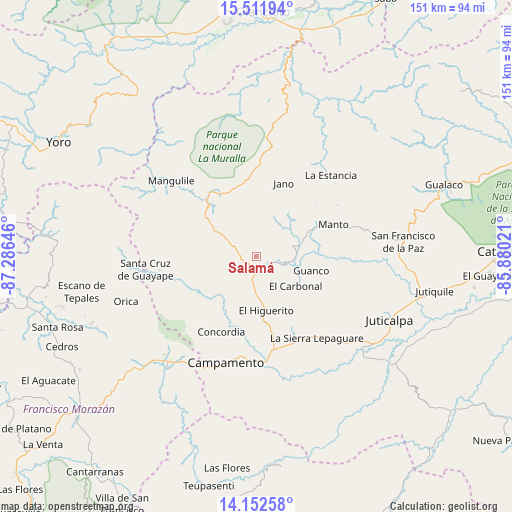
Salamá GPS coordinates[2]
14° 49' 59.988" North, 86° 34' 59.988" West
| Map corner | latitude | longitude |
|---|---|---|
| Upper-left | 15.51194°, | -87.28646° |
| Center: | 14.83333°, | -86.58333° |
| Lower-right: | 14.15258°, | -85.88021° |
| Map W x H: | 151.1×151.1 km | = 93.9×93.9mi |
| max Lat: | 16.45° ⇑53% North |
| Salamá: | 14.83333° |
| min Lat: | ⇓47% South 13.11667° |
| min Long | Salamá | max Long |
| -89.23333° | -86.58333° | -83.23333° |
| W 82.6%⇐ | ⇒17.4% E |
Elevation
Elevation of Salamá is 670 m = 2198 ft, and this is 108.8 m = 357 ft above average elevation for this country.
| Max E: |
1811 m = 5942 ft | 40.2% |
| Salamá | 670 m 2198 ft | |
| Avg. | 561.2 m = 1841 ft | |
Min E: |
1 m = 3 ft | 59.8% |
See also: Honduras elevation on elevation.city.
Geographical zone
Salamá is located in North Torrid zone (between Equator and Tropic of Cancer). Distance of this Northern Tropic circle is 956.6 km =594.4 mi to North.| Distance of | km | miles | from Salamá |
|---|---|---|---|
| North Pole | 8357.8 | 5193.3 | to North |
| Arctic Circle | 5751.9 | 3574.1 | to North |
| Tropic Cancer | 956.6 | 594.4 | to North |
| Equator | 1649.3 | 1024.8 | to South |


Nearby cities:
15 places around Salamá: (largest is in red/bold)
• Campamento
32.3 km =20.1 mi,  192°
192°
• Concordia
25.1 km =15.6 mi,  196°
196°
• El Rosario
13.1 km =8.1 mi,  304°
304°
• Guaimaca
41.7 km =25.9 mi,  216°
216°
• Guarizama
28.4 km =17.6 mi,  70°
70°
• Guayape
29.8 km =18.5 mi,  244°
244°
• La Concepción
40.4 km =25.1 mi,  111°
111°
• La Estancia
34.8 km =21.6 mi,  46°
46°
• La Guata
35.1 km =21.8 mi,  37°
37°
• Mangulile
34.9 km =21.7 mi,  318°
318°
• Manto
23.4 km =14.5 mi, 66°
• Orica
42.1 km =26.2 mi,  249°
249°
• Sabana Abajo
25.9 km =16.1 mi,  180°
180°
• San Francisco de la Paz
41.9 km =26 mi,  79°
79°
• Silca
5.4 km =3.4 mi,  90°
90°
Sources, notices
• [Note1] Compared only with cities in Honduras existing in our database
• [Src1] Map data: © OpenStreetMap contributors (CC-BY-SA)
• [Src2] Other city data from geonames.org with taken over terms of usage.
• [Src3] Geographical zone / Annual Mean Temperature by Robert A. Rohde @ Wikipedia
