Mangulile geodata
Mangulile (Olancho) is a populated place; located in Honduras in America/Tegucigalpa (GMT-6) time zone. With population of 1,263 people, there are 303 cities with bigger population in this country. Compared to other cities in Honduras, 62.2% of cities are located further ↓South; 79% of cities are located further ←West and 87.4% of cities have lower elevation than Mangulile. Note1


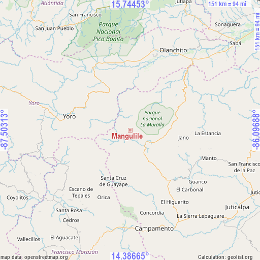
Mangulile GPS coordinates[2]
15° 4' 0.012" North, 86° 48' 0" West
| Map corner | latitude | longitude |
|---|---|---|
| Upper-left | 15.74453°, | -87.50313° |
| Center: | 15.06667°, | -86.8° |
| Lower-right: | 14.38665°, | -86.09688° |
| Map W x H: | 151×151 km | = 93.8×93.8mi |
| max Lat: | 16.45° ⇑37.8% North |
| Mangulile: | 15.06667° |
| min Lat: | ⇓62.2% South 13.11667° |
| min Long | Mangulile | max Long |
| -89.23333° | -86.8° | -83.23333° |
| W 79%⇐ | ⇒21% E |
Elevation
Elevation of Mangulile is 1099 m = 3606 ft, and this is 537.8 m = 1764 ft above average elevation for this country.
| Max E: |
1811 m = 5942 ft | 12.6% |
| Mangulile | 1099 m 3606 ft | |
| Avg. | 561.2 m = 1841 ft | |
Min E: |
1 m = 3 ft | 87.4% |
See also: Honduras elevation on elevation.city.
Geographical zone
Mangulile is located in North Torrid zone (between Equator and Tropic of Cancer). Distance of this Northern Tropic circle is 930.7 km =578.3 mi to North.| Distance of | km | miles | from Mangulile |
|---|---|---|---|
| North Pole | 8331.8 | 5177.1 | to North |
| Arctic Circle | 5725.9 | 3557.9 | to North |
| Tropic Cancer | 930.7 | 578.3 | to North |
| Equator | 1675.3 | 1041 | to South |


Nearby cities:
15 places around Mangulile: (largest is in red/bold)
• Arenal
31.7 km =19.7 mi,  353°
353°
• Ayapa
40.6 km =25.2 mi,  277°
277°
• Coyoles Central
39.7 km =24.7 mi,  21°
21°
• El Rosario
22.4 km =13.9 mi,  145°
145°
• Guayape
39.1 km =24.3 mi,  185°
185°
• Jocón
30 km =18.6 mi,  323°
323°
• La Rosa
42.6 km =26.5 mi, 317°
• La Trinidad
43.1 km =26.8 mi,  274°
274°
• Marale
42.8 km =26.6 mi,  241°
241°
• Nombre de Jesús
33.9 km =21.1 mi, 21°
• Salamá
34.9 km =21.7 mi,  138°
138°
• Silca
38.6 km =24 mi,  132°
132°
• Teguajinal
39.7 km =24.7 mi,  32°
32°
• Trojas
33.3 km =20.7 mi, 18°
• Yoro
36.1 km =22.4 mi, 282°
Sources, notices
• [Note1] Compared only with cities in Honduras existing in our database
• [Src1] Map data: © OpenStreetMap contributors (CC-BY-SA)
• [Src2] Other city data from geonames.org with taken over terms of usage.
• [Src3] Geographical zone / Annual Mean Temperature by Robert A. Rohde @ Wikipedia
