Nuevo Celilac geodata
Nuevo Celilac (Santa Bárbara) is a populated place; located in Honduras in America/Tegucigalpa (GMT-6) time zone. With population of 950 people, there are 450 cities with bigger population in this country. Compared to other cities in Honduras, 56.4% of cities are located further ↓South; 79.2% of cities are located further →East and 54% of cities have higher elevation than Nuevo Celilac. Note1


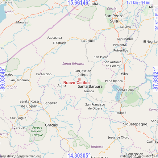
Nuevo Celilac GPS coordinates[2]
14° 58' 59.988" North, 88° 19' 59.988" West
| Map corner | latitude | longitude |
|---|---|---|
| Upper-left | 15.66146°, | -89.03646° |
| Center: | 14.98333°, | -88.33333° |
| Lower-right: | 14.30305°, | -87.63021° |
| Map W x H: | 151×151 km | = 93.8×93.8mi |
| max Lat: | 16.45° ⇑43.6% North |
| Nuevo Celilac: | 14.98333° |
| min Lat: | ⇓56.4% South 13.11667° |
| min Long | Nuevo Celilac | max Long |
| -89.23333° | -88.33333° | -83.23333° |
| W 20.8%⇐ | ⇒79.2% E |
Elevation
Elevation of Nuevo Celilac is 506 m = 1660 ft, and this is 55.2 m = 181 ft below average elevation for this country.
| Max E: |
1811 m = 5942 ft | 54% |
| Avg. | 561.2 m = 1841 ft | |
| Nuevo Celilac | 506 m = 1660 ft | |
Min E: |
1 m = 3 ft | 46% |
See also: Honduras elevation on elevation.city.
Geographical zone
Nuevo Celilac is located in North Torrid zone (between Equator and Tropic of Cancer). Distance of this Northern Tropic circle is 939.9 km =584 mi to North.| Distance of | km | miles | from Nuevo Celilac |
|---|---|---|---|
| North Pole | 8341.1 | 5182.9 | to North |
| Arctic Circle | 5735.2 | 3563.7 | to North |
| Tropic Cancer | 939.9 | 584 | to North |
| Equator | 1666 | 1035.2 | to South |


Nearby cities:
15 places around Nuevo Celilac: (largest is in red/bold)
• Arada
15.3 km =9.5 mi,  166°
166°
• Atima
17 km =10.6 mi,  250°
250°
• Guacamaya
20 km =12.4 mi,  79°
79°
• Gualjoco
11.4 km =7.1 mi,  109°
109°
• Ilama
15.6 km =9.7 mi,  53°
53°
• La Unión
19.9 km =12.4 mi,  201°
201°
• Macholoa
8.2 km =5.1 mi,  154°
154°
• Nueva Jalapa
7.4 km =4.6 mi,  180°
180°
• San José de Colinas
6.6 km =4.1 mi,  32°
32°
• San Luis
12.3 km =7.6 mi,  334°
334°
• San Nicolás
5.8 km =3.6 mi,  162°
162°
• San Vicente Centenario
12.3 km =7.6 mi, 154°
• Santa Bárbara
12.6 km =7.8 mi,  124°
124°
• Santa Rita
14.6 km =9.1 mi, 120°
• Trinidad
19.8 km =12.3 mi, 32°
Sources, notices
• [Note1] Compared only with cities in Honduras existing in our database
• [Src1] Map data: © OpenStreetMap contributors (CC-BY-SA)
• [Src2] Other city data from geonames.org with taken over terms of usage.
• [Src3] Geographical zone / Annual Mean Temperature by Robert A. Rohde @ Wikipedia
