Namasigüe geodata
Namasigüe (Choluteca) is a populated place; located in Honduras in America/Tegucigalpa (GMT-6) time zone. With population of 1,804 people, there are 203 cities with bigger population in this country. Compared to other cities in Honduras, 98.8% of cities are located further ↑North; 68.4% of cities are located further ←West and 82.8% of cities have higher elevation than Namasigüe. Note1


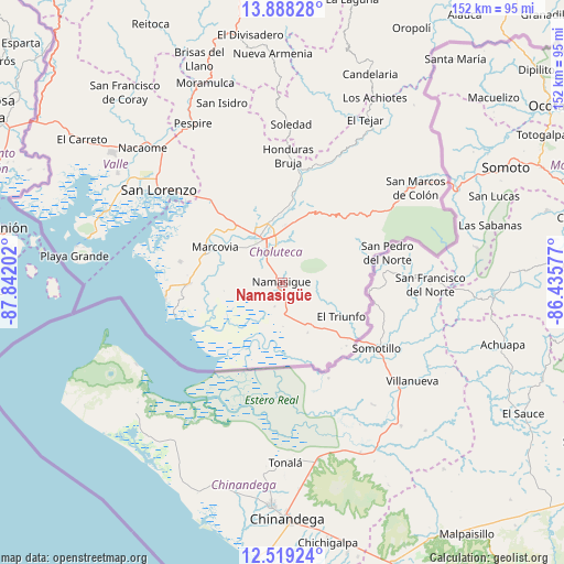
Namasigüe GPS coordinates[2]
13° 12' 16.992" North, 87° 8' 20.004" West
| Map corner | latitude | longitude |
|---|---|---|
| Upper-left | 13.88828°, | -87.84202° |
| Center: | 13.20472°, | -87.13889° |
| Lower-right: | 12.51924°, | -86.43577° |
| Map W x H: | 152.2×152.2 km | = 94.6×94.6mi |
| max Lat: | 16.45° ⇑98.8% North |
| Namasigüe: | 13.20472° |
| min Lat: | ⇓1.2% South 13.11667° |
| min Long | Namasigüe | max Long |
| -89.23333° | -87.13889° | -83.23333° |
| W 68.4%⇐ | ⇒31.6% E |
Elevation
Elevation of Namasigüe is 54 m = 177 ft, and this is 507.2 m = 1664 ft below average elevation for this country.
| Max E: |
1811 m = 5942 ft | 82.8% |
| Avg. | 561.2 m = 1841 ft | |
| Namasigüe | 54 m = 177 ft | |
Min E: |
1 m = 3 ft | 17.2% |
See also: Honduras elevation on elevation.city.
Geographical zone
Namasigüe is located in North Torrid zone (between Equator and Tropic of Cancer). Distance of this Northern Tropic circle is 1137.7 km =706.9 mi to North.| Distance of | km | miles | from Namasigüe |
|---|---|---|---|
| North Pole | 8538.8 | 5305.8 | to North |
| Arctic Circle | 5932.9 | 3686.5 | to North |
| Tropic Cancer | 1137.7 | 706.9 | to North |
| Equator | 1468.2 | 912.3 | to South |


Nearby cities:
15 places around Namasigüe: (largest is in red/bold)
• Agua Caliente de Linaca
27.5 km =17.1 mi,  338°
338°
• Ciudad Choluteca
12 km =7.5 mi,  332°
332°
• Concepción de María
15.1 km =9.4 mi,  84°
84°
• Corpus
14.7 km =9.1 mi,  50°
50°
• El Obraje
5.7 km =3.5 mi,  171°
171°
• El Perico
13.7 km =8.5 mi,  122°
122°
• El Puente
9.1 km =5.7 mi,  15°
15°
• El Triunfo
17.9 km =11.1 mi, 123°
• Los Llanitos
23.1 km =14.4 mi,  293°
293°
• Marcovia
20.7 km =12.9 mi,  296°
296°
• Monjarás
25.5 km =15.8 mi,  268°
268°
• San Agustín
2.5 km =1.6 mi,  102°
102°
• San Jerónimo
3.1 km =1.9 mi,  175°
175°
• Santa Ana de Yusguare
11 km =6.8 mi,  14°
14°
• Santa Cruz
23.4 km =14.5 mi,  284°
284°
Sources, notices
• [Note1] Compared only with cities in Honduras existing in our database
• [Src1] Map data: © OpenStreetMap contributors (CC-BY-SA)
• [Src2] Other city data from geonames.org with taken over terms of usage.
• [Src3] Geographical zone / Annual Mean Temperature by Robert A. Rohde @ Wikipedia
