Los Llanitos geodata
Los Llanitos (Choluteca) is a populated place; located in Honduras in America/Tegucigalpa (GMT-6) time zone. With population of 1,040 people, there are 397 cities with bigger population in this country. Compared to other cities in Honduras, 98% of cities are located further ↑North; 60.6% of cities are located further ←West and 89.8% of cities have higher elevation than Los Llanitos. Note1


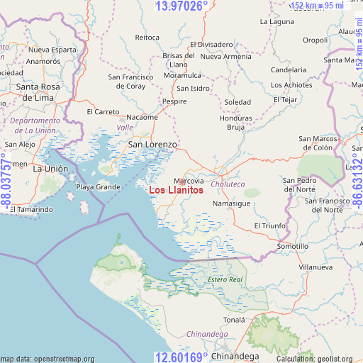
Los Llanitos GPS coordinates[2]
13° 17' 12.984" North, 87° 20' 3.984" West
| Map corner | latitude | longitude |
|---|---|---|
| Upper-left | 13.97026°, | -88.03757° |
| Center: | 13.28694°, | -87.33444° |
| Lower-right: | 12.60169°, | -86.63132° |
| Map W x H: | 152.2×152.2 km | = 94.6×94.6mi |
| max Lat: | 16.45° ⇑98% North |
| Los Llanitos: | 13.28694° |
| min Lat: | ⇓2% South 13.11667° |
| min Long | Los Llanitos | max Long |
| -89.23333° | -87.33444° | -83.23333° |
| W 60.6%⇐ | ⇒39.4% E |
Elevation
Elevation of Los Llanitos is 25 m = 82 ft, and this is 536.2 m = 1759 ft below average elevation for this country.
| Max E: |
1811 m = 5942 ft | 89.8% |
| Avg. | 561.2 m = 1841 ft | |
| Los Llanitos | 25 m = 82 ft | |
Min E: |
1 m = 3 ft | 10.2% |
See also: Honduras elevation on elevation.city.
Geographical zone
Los Llanitos is located in North Torrid zone (between Equator and Tropic of Cancer). Distance of this Northern Tropic circle is 1128.5 km =701.2 mi to North.| Distance of | km | miles | from Los Llanitos |
|---|---|---|---|
| North Pole | 8529.7 | 5300.1 | to North |
| Arctic Circle | 5923.8 | 3680.9 | to North |
| Tropic Cancer | 1128.5 | 701.2 | to North |
| Equator | 1477.4 | 918 | to South |


Nearby cities:
15 places around Los Llanitos: (largest is in red/bold)
• Agua Caliente de Linaca
19.9 km =12.4 mi,  33°
33°
• Ciudad Choluteca
15.6 km =9.7 mi,  84°
84°
• El Guayabo
25.4 km =15.8 mi,  332°
332°
• El Obraje
26.5 km =16.5 mi,  123°
123°
• El Puente
23.6 km =14.7 mi,  90°
90°
• La Criba
20.4 km =12.7 mi,  335°
335°
• Marcovia
2.7 km =1.7 mi, 87°
• Monjarás
10.5 km =6.5 mi,  204°
204°
• Namasigüe
23.1 km =14.4 mi,  113°
113°
• San Agustín
25.5 km =15.8 mi, 112°
• San Jerónimo
24.7 km =15.3 mi, 119°
• San José de Las Conchas
7.9 km =4.9 mi,  302°
302°
• San Lorenzo
19.5 km =12.1 mi,  321°
321°
• Santa Ana de Yusguare
23.9 km =14.9 mi, 86°
• Santa Cruz
3.5 km =2.2 mi,  205°
205°
Sources, notices
• [Note1] Compared only with cities in Honduras existing in our database
• [Src1] Map data: © OpenStreetMap contributors (CC-BY-SA)
• [Src2] Other city data from geonames.org with taken over terms of usage.
• [Src3] Geographical zone / Annual Mean Temperature by Robert A. Rohde @ Wikipedia
