Marcovia geodata
Marcovia (Choluteca) is a populated place; located in Honduras in America/Tegucigalpa (GMT-6) time zone. With population of 1,928 people, there are 187 cities with bigger population in this country. Compared to other cities in Honduras, 97.8% of cities are located further ↑North; 61.6% of cities are located further ←West and 90.4% of cities have higher elevation than Marcovia. Note1


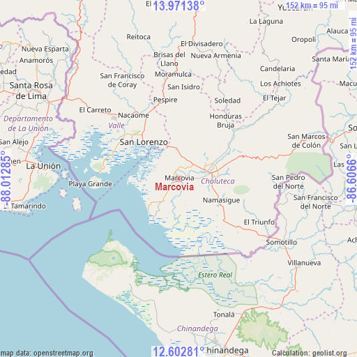
Marcovia GPS coordinates[2]
13° 17' 17.016" North, 87° 18' 34.992" West
| Map corner | latitude | longitude |
|---|---|---|
| Upper-left | 13.97138°, | -88.01285° |
| Center: | 13.28806°, | -87.30972° |
| Lower-right: | 12.60281°, | -86.6066° |
| Map W x H: | 152.2×152.2 km | = 94.6×94.6mi |
| max Lat: | 16.45° ⇑97.8% North |
| Marcovia: | 13.28806° |
| min Lat: | ⇓2.2% South 13.11667° |
| min Long | Marcovia | max Long |
| -89.23333° | -87.30972° | -83.23333° |
| W 61.6%⇐ | ⇒38.4% E |
Elevation
Elevation of Marcovia is 23 m = 75 ft, and this is 538.2 m = 1766 ft below average elevation for this country.
| Max E: |
1811 m = 5942 ft | 90.4% |
| Avg. | 561.2 m = 1841 ft | |
| Marcovia | 23 m = 75 ft | |
Min E: |
1 m = 3 ft | 9.6% |
See also: Honduras elevation on elevation.city.
Geographical zone
Marcovia is located in North Torrid zone (between Equator and Tropic of Cancer). Distance of this Northern Tropic circle is 1128.4 km =701.2 mi to North.| Distance of | km | miles | from Marcovia |
|---|---|---|---|
| North Pole | 8529.6 | 5300 | to North |
| Arctic Circle | 5923.7 | 3680.8 | to North |
| Tropic Cancer | 1128.4 | 701.2 | to North |
| Equator | 1477.5 | 918.1 | to South |


Nearby cities:
15 places around Marcovia: (largest is in red/bold)
• Agua Caliente de Linaca
18.4 km =11.4 mi,  27°
27°
• Ciudad Choluteca
12.9 km =8 mi,  83°
83°
• El Guayabo
26.7 km =16.6 mi,  327°
327°
• El Obraje
24.4 km =15.2 mi,  127°
127°
• El Puente
20.9 km =13 mi,  91°
91°
• La Criba
21.6 km =13.4 mi, 328°
• Los Llanitos
2.7 km =1.7 mi,  267°
267°
• Monjarás
12 km =7.5 mi,  215°
215°
• Namasigüe
20.7 km =12.9 mi,  116°
116°
• San Agustín
23.1 km =14.4 mi, 115°
• San Jerónimo
22.5 km =14 mi, 123°
• San José de Las Conchas
10.2 km =6.3 mi,  294°
294°
• San Lorenzo
21.2 km =13.2 mi,  315°
315°
• Santa Ana de Yusguare
21.2 km =13.2 mi, 86°
• Santa Cruz
5.3 km =3.3 mi,  231°
231°
Sources, notices
• [Note1] Compared only with cities in Honduras existing in our database
• [Src1] Map data: © OpenStreetMap contributors (CC-BY-SA)
• [Src2] Other city data from geonames.org with taken over terms of usage.
• [Src3] Geographical zone / Annual Mean Temperature by Robert A. Rohde @ Wikipedia
