El Guayabo geodata
El Guayabo (Valle) is a populated place; located in Honduras in America/Tegucigalpa (GMT-6) time zone. With population of 889 people, there are 484 cities with bigger population in this country. Compared to other cities in Honduras, 94.8% of cities are located further ↑North; 56.6% of cities are located further ←West and 86.4% of cities have higher elevation than El Guayabo. Note1


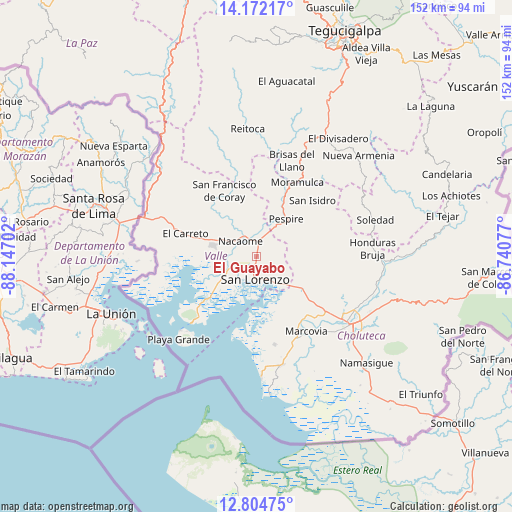
El Guayabo GPS coordinates[2]
13° 29' 21.984" North, 87° 26' 38.004" West
| Map corner | latitude | longitude |
|---|---|---|
| Upper-left | 14.17217°, | -88.14702° |
| Center: | 13.48944°, | -87.44389° |
| Lower-right: | 12.80475°, | -86.74077° |
| Map W x H: | 152×152 km | = 94.4×94.4mi |
| max Lat: | 16.45° ⇑94.8% North |
| El Guayabo: | 13.48944° |
| min Lat: | ⇓5.2% South 13.11667° |
| min Long | El Guayabo | max Long |
| -89.23333° | -87.44389° | -83.23333° |
| W 56.6%⇐ | ⇒43.4% E |
Elevation
Elevation of El Guayabo is 38 m = 125 ft, and this is 523.2 m = 1717 ft below average elevation for this country.
| Max E: |
1811 m = 5942 ft | 86.4% |
| Avg. | 561.2 m = 1841 ft | |
| El Guayabo | 38 m = 125 ft | |
Min E: |
1 m = 3 ft | 13.6% |
See also: Honduras elevation on elevation.city.
Geographical zone
El Guayabo is located in North Torrid zone (between Equator and Tropic of Cancer). Distance of this Northern Tropic circle is 1106 km =687.2 mi to North.| Distance of | km | miles | from El Guayabo |
|---|---|---|---|
| North Pole | 8507.2 | 5286.1 | to North |
| Arctic Circle | 5901.3 | 3666.9 | to North |
| Tropic Cancer | 1106 | 687.2 | to North |
| Equator | 1499.9 | 932 | to South |


Nearby cities:
15 places around El Guayabo: (largest is in red/bold)
• Agua Caliente de Linaca
23.7 km =14.7 mi,  104°
104°
• Agua Fría
11.8 km =7.3 mi,  258°
258°
• El Cubolero
24.2 km =15 mi, 264°
• El Tular
8.1 km =5 mi,  251°
251°
• Goascorán
21.4 km =13.3 mi,  299°
299°
• Jícaro Galán
4.7 km =2.9 mi,  6°
6°
• La Criba
5.2 km =3.2 mi,  140°
140°
• Langue
26.9 km =16.7 mi, 302°
• Los Llanitos
25.4 km =15.8 mi,  152°
152°
• Marcovia
26.7 km =16.6 mi, 147°
• Nacaome
7 km =4.3 mi,  317°
317°
• Pespire
14.5 km =9 mi,  37°
37°
• San Francisco de Coray
21.4 km =13.3 mi,  333°
333°
• San José de Las Conchas
19 km =11.8 mi,  164°
164°
• San Lorenzo
7.3 km =4.5 mi,  182°
182°
Sources, notices
• [Note1] Compared only with cities in Honduras existing in our database
• [Src1] Map data: © OpenStreetMap contributors (CC-BY-SA)
• [Src2] Other city data from geonames.org with taken over terms of usage.
• [Src3] Geographical zone / Annual Mean Temperature by Robert A. Rohde @ Wikipedia
