La Libertad geodata
La Libertad (Comayagua) is a populated place; located in Honduras in America/Tegucigalpa (GMT-6) time zone. With population of 4,673 people, there are 68 cities with bigger population in this country. Compared to other cities in Honduras, 58.4% of cities are located further ↑North; 50.4% of cities are located further ←West and 62.8% of cities have higher elevation than La Libertad. Note1


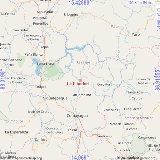
La Libertad GPS coordinates[2]
14° 45' 0" North, 87° 37' 0.012" West
| Map corner | latitude | longitude |
|---|---|---|
| Upper-left | 15.42888°, | -88.3198° |
| Center: | 14.75°, | -87.61667° |
| Lower-right: | 14.069°, | -86.91355° |
| Map W x H: | 151.2×151.2 km | = 94×94mi |
| max Lat: | 16.45° ⇑58.4% North |
| La Libertad: | 14.75° |
| min Lat: | ⇓41.6% South 13.11667° |
| min Long | La Libertad | max Long |
| -89.23333° | -87.61667° | -83.23333° |
| W 50.4%⇐ | ⇒49.6% E |
Elevation
Elevation of La Libertad is 363 m = 1191 ft, and this is 198.2 m = 650 ft below average elevation for this country.
| Max E: |
1811 m = 5942 ft | 62.8% |
| Avg. | 561.2 m = 1841 ft | |
| La Libertad | 363 m = 1191 ft | |
Min E: |
1 m = 3 ft | 37.2% |
See also: Honduras elevation on elevation.city.
Geographical zone
La Libertad is located in North Torrid zone (between Equator and Tropic of Cancer). Distance of this Northern Tropic circle is 965.9 km =600.2 mi to North.| Distance of | km | miles | from La Libertad |
|---|---|---|---|
| North Pole | 8367 | 5199 | to North |
| Arctic Circle | 5761.1 | 3579.8 | to North |
| Tropic Cancer | 965.9 | 600.2 | to North |
| Equator | 1640 | 1019 | to South |


Nearby cities:
15 places around La Libertad: (largest is in red/bold)
• Cerro Blanco
20.2 km =12.6 mi,  242°
242°
• Concepción de Guasistagua
17.1 km =10.6 mi,  192°
192°
• El Agua Dulcita
15.4 km =9.6 mi,  248°
248°
• El Buen Pastor
22.1 km =13.7 mi,  305°
305°
• El Rancho
14.6 km =9.1 mi,  120°
120°
• El Rosario
17.1 km =10.6 mi,  289°
289°
• El Sauce
25.2 km =15.7 mi, 192°
• Esquías
26.9 km =16.7 mi,  93°
93°
• Jamalteca
6.6 km =4.1 mi,  147°
147°
• La Trinidad
6.5 km =4 mi, 235°
• Las Lajas
14.8 km =9.2 mi,  284°
284°
• Meámbar
16.5 km =10.3 mi, 282°
• San Antonio de la Cuesta
13.1 km =8.1 mi,  172°
172°
• San Jerónimo
13.1 km =8.1 mi, 172°
• San Luis
21.5 km =13.4 mi, 90°
Sources, notices
• [Note1] Compared only with cities in Honduras existing in our database
• [Src1] Map data: © OpenStreetMap contributors (CC-BY-SA)
• [Src2] Other city data from geonames.org with taken over terms of usage.
• [Src3] Geographical zone / Annual Mean Temperature by Robert A. Rohde @ Wikipedia
