La Esperanza geodata
La Esperanza (Intibucá) is a seat of a first-order administrative division; located in Honduras in America/Tegucigalpa (GMT-6) time zone. With population of 5,318 people, there are 62 cities with bigger population in this country. Compared to other cities in Honduras, 77.2% of cities are located further ↑North; 74% of cities are located further →East and 99.2% of cities have lower elevation than La Esperanza. Note1


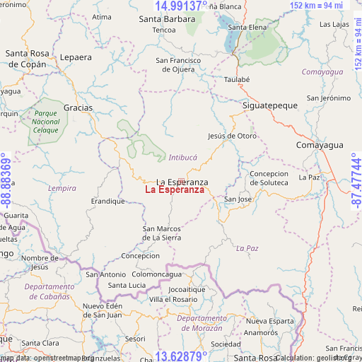
La Esperanza GPS coordinates[2]
14° 18' 39.996" North, 88° 10' 50.016" West
| Map corner | latitude | longitude |
|---|---|---|
| Upper-left | 14.99137°, | -88.88369° |
| Center: | 14.31111°, | -88.18056° |
| Lower-right: | 13.62879°, | -87.47744° |
| Map W x H: | 151.5×151.5 km | = 94.1×94.1mi |
| max Lat: | 16.45° ⇑77.2% North |
| La Esperanza: | 14.31111° |
| min Lat: | ⇓22.8% South 13.11667° |
| min Long | La Esperanza | max Long |
| -89.23333° | -88.18056° | -83.23333° |
| W 26%⇐ | ⇒74% E |
Elevation
Elevation of La Esperanza is 1697 m = 5568 ft, and this is 1135.8 m = 3726 ft above average elevation for this country.
| Max E: |
1811 m = 5942 ft | 0.8% |
| La Esperanza | 1697 m 5568 ft | |
| Avg. | 561.2 m = 1841 ft | |
Min E: |
1 m = 3 ft | 99.2% |
See also: Honduras elevation on elevation.city.
Geographical zone
La Esperanza is located in North Torrid zone (between Equator and Tropic of Cancer). Distance of this Northern Tropic circle is 1014.7 km =630.5 mi to North.| Distance of | km | miles | from La Esperanza |
|---|---|---|---|
| North Pole | 8415.8 | 5229.3 | to North |
| Arctic Circle | 5809.9 | 3610.1 | to North |
| Tropic Cancer | 1014.7 | 630.5 | to North |
| Equator | 1591.2 | 988.7 | to South |


Nearby cities:
15 places around La Esperanza: (largest is in red/bold)
• Azacualpa
22.4 km =13.9 mi,  257°
257°
• Camasca
40.9 km =25.4 mi,  212°
212°
• El Rincón
40.3 km =25 mi,  41°
41°
• Erandique
32 km =19.9 mi,  254°
254°
• Intibucá
1.6 km =1 mi,  67°
67°
• Jesús de Otoro
28.6 km =17.8 mi,  47°
47°
• Jiquinlaca
39.1 km =24.3 mi, 207°
• La Florida
34.5 km =21.4 mi,  141°
141°
• Los Planes
34 km =21.1 mi,  148°
148°
• Marcala
23.9 km =14.9 mi, 138°
• Ojos de Agua
41.7 km =25.9 mi, 39°
• San José
25.8 km =16 mi,  105°
105°
• San Pedro de Tutule
36.3 km =22.6 mi,  100°
100°
• Santiago Puringla
30.5 km =19 mi,  81°
81°
• Yamaranguila
8.1 km =5 mi, 247°
Sources, notices
• [Note1] Compared only with cities in Honduras existing in our database
• [Src1] Map data: © OpenStreetMap contributors (CC-BY-SA)
• [Src2] Other city data from geonames.org with taken over terms of usage.
• [Src3] Geographical zone / Annual Mean Temperature by Robert A. Rohde @ Wikipedia
