Azacualpa geodata
Azacualpa (Intibucá) is a populated place; located in Honduras in America/Tegucigalpa (GMT-6) time zone. With population of 966 people, there are 438 cities with bigger population in this country. Compared to other cities in Honduras, 79% of cities are located further ↑North; 80.2% of cities are located further →East and 89.4% of cities have lower elevation than Azacualpa. Note1


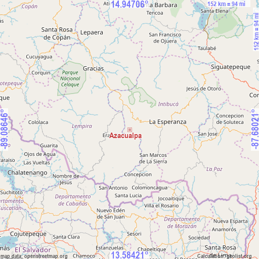
Azacualpa GPS coordinates[2]
14° 16' 0.012" North, 88° 22' 59.988" West
| Map corner | latitude | longitude |
|---|---|---|
| Upper-left | 14.94706°, | -89.08646° |
| Center: | 14.26667°, | -88.38333° |
| Lower-right: | 13.58421°, | -87.68021° |
| Map W x H: | 151.5×151.5 km | = 94.1×94.1mi |
| max Lat: | 16.45° ⇑79% North |
| Azacualpa: | 14.26667° |
| min Lat: | ⇓21% South 13.11667° |
| min Long | Azacualpa | max Long |
| -89.23333° | -88.38333° | -83.23333° |
| W 19.8%⇐ | ⇒80.2% E |
Elevation
Elevation of Azacualpa is 1136 m = 3727 ft, and this is 574.8 m = 1886 ft above average elevation for this country.
| Max E: |
1811 m = 5942 ft | 10.6% |
| Azacualpa | 1136 m 3727 ft | |
| Avg. | 561.2 m = 1841 ft | |
Min E: |
1 m = 3 ft | 89.4% |
See also: Honduras elevation on elevation.city.
Geographical zone
Azacualpa is located in North Torrid zone (between Equator and Tropic of Cancer). Distance of this Northern Tropic circle is 1019.6 km =633.5 mi to North.| Distance of | km | miles | from Azacualpa |
|---|---|---|---|
| North Pole | 8420.8 | 5232.4 | to North |
| Arctic Circle | 5814.9 | 3613.2 | to North |
| Tropic Cancer | 1019.6 | 633.5 | to North |
| Equator | 1586.3 | 985.7 | to South |


Nearby cities:
15 places around Azacualpa: (largest is in red/bold)
• Camasca
29.7 km =18.5 mi,  180°
180°
• El Achiotal
44.5 km =27.7 mi,  242°
242°
• Erandique
9.7 km =6 mi,  247°
247°
• Gracias
41.9 km =26 mi,  329°
329°
• Guatemalita
30.2 km =18.8 mi, 236°
• Intibucá
24 km =14.9 mi,  76°
76°
• Jiquinlaca
29.9 km =18.6 mi,  173°
173°
• La Esperanza
22.4 km =13.9 mi, 77°
• La Virtud
41.8 km =26 mi,  234°
234°
• Lagunas
40.4 km =25.1 mi,  344°
344°
• Los Planes
46.3 km =28.8 mi,  121°
121°
• Magdalena
45.4 km =28.2 mi, 168°
• Marcala
39.9 km =24.8 mi,  108°
108°
• San José
46.7 km =29 mi,  92°
92°
• Yamaranguila
14.5 km =9 mi, 82°
Sources, notices
• [Note1] Compared only with cities in Honduras existing in our database
• [Src1] Map data: © OpenStreetMap contributors (CC-BY-SA)
• [Src2] Other city data from geonames.org with taken over terms of usage.
• [Src3] Geographical zone / Annual Mean Temperature by Robert A. Rohde @ Wikipedia
