Guanaja geodata
Guanaja (Bay Islands) is a populated place; located in Honduras in America/Tegucigalpa (GMT-6) time zone. With population of 1,942 people, there are 186 cities with bigger population in this country. Compared to other cities in Honduras, 99.8% of cities are located further ↓South; 95.4% of cities are located further ←West and 81.8% of cities have higher elevation than Guanaja. Note1


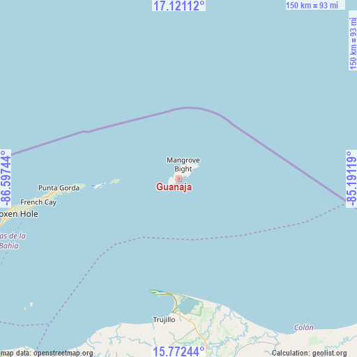
Guanaja GPS coordinates[2]
16° 26' 52.62" North, 85° 53' 39.516" West
| Map corner | latitude | longitude |
|---|---|---|
| Upper-left | 17.12112°, | -86.59744° |
| Center: | 16.44795°, | -85.89431° |
| Lower-right: | 15.77244°, | -85.19119° |
| Map W x H: | 150×150 km | = 93.2×93.2mi |
| max Lat: | 16.45° ⇑0.2% North |
| Guanaja: | 16.44795° |
| min Lat: | ⇓99.8% South 13.11667° |
| min Long | Guanaja | max Long |
| -89.23333° | -85.89431° | -83.23333° |
| W 95.4%⇐ | ⇒4.6% E |
Elevation
Elevation of Guanaja is 60 m = 197 ft, and this is 501.2 m = 1644 ft below average elevation for this country.
| Max E: |
1811 m = 5942 ft | 81.8% |
| Avg. | 561.2 m = 1841 ft | |
| Guanaja | 60 m = 197 ft | |
Min E: |
1 m = 3 ft | 18.2% |
See also: Honduras elevation on elevation.city.
Geographical zone
Guanaja is located in North Torrid zone (between Equator and Tropic of Cancer). Distance of this Northern Tropic circle is 777.1 km =482.9 mi to North.| Distance of | km | miles | from Guanaja |
|---|---|---|---|
| North Pole | 8178.2 | 5081.7 | to North |
| Arctic Circle | 5572.3 | 3462.5 | to North |
| Tropic Cancer | 777.1 | 482.9 | to North |
| Equator | 1828.8 | 1136.4 | to South |


Nearby cities:
15 places around Guanaja: (largest is in red/bold)
• Bonito Oriental
79.7 km =49.5 mi,  167°
167°
• Corocito
78.5 km =48.8 mi, 171°
• Coxen Hole
70.2 km =43.6 mi,  258°
258°
• Francia
74.3 km =46.2 mi,  153°
153°
• French Harbor
58.5 km =36.4 mi, 259°
• Jericó
55.9 km =34.7 mi,  187°
187°
• La Brea
72.5 km =45 mi, 186°
• La Curva
73.3 km =45.5 mi, 169°
• Puerto Castilla
48.6 km =30.2 mi, 189°
• Quebrada de Arena
75.8 km =47.1 mi,  181°
181°
• Salamá
78 km =48.5 mi, 185°
• Sandy Bay
72.7 km =45.2 mi, 259°
• Santa Rosa de Aguán
58.5 km =36.4 mi,  161°
161°
• Savannah Bight
4.7 km =2.9 mi,  87°
87°
• Trujillo
59.4 km =36.9 mi, 186°
Sources, notices
• [Note1] Compared only with cities in Honduras existing in our database
• [Src1] Map data: © OpenStreetMap contributors (CC-BY-SA)
• [Src2] Other city data from geonames.org with taken over terms of usage.
• [Src3] Geographical zone / Annual Mean Temperature by Robert A. Rohde @ Wikipedia
